The Norfolk Forest-Bed
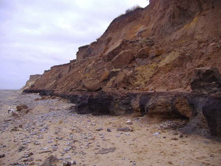
Chapter V of Immanuel Velikovsky’s Earth in Upheaval is entitled Tidal Wave. The six sections of this chapter review the scientific evidence for catastrophic floods and mega-tsunamis in the Earth’s recent past. In section two, The Norfolk Forest-Bed, Velikovsky discusses a strange geological formation in the east of England known today as the Cromer Forest Bed. These fossiliferous sediments of clays, muds, sands, and gravels were laid down along the North Sea coast of Norfolk during the last Ice Age. The deposits are about 6 m thick and contain a remarkable assemblage of fossilized mammals and birds.
The existence of this formation was first brought to scholarly light by the English naturalist William Arderon, whose letter on the “Precipices or Cliffs on the North-East Coast of the County of Norfolk” was published in 1746 in Volume 44 of The Royal Society’s Philosophical Transactions. Arderon was the first to deduce that this part of the coast had been repeatedly inundated by the sea:
Vegetable Mould, Oaz [Ooze?], Sands of various Kinds and Colours, Clays, Loams, Flints, Marles, Chalk, Pebbles, &c. are here to be seen at one View beautifully interspersed; and frequently the same kind many times repeated; as if at one time dry Land had been the Surface; then the Sea; after, morassy Ground; then the Sea, and so on, till these Cliffs were raised to the Height we now find them.
What makes this come up almost to Demonstration, are the Roots and Trunks of Trees, which are to be seen at low Water in several Places on this Coast near Hasborough and Walket ... that Bones of Animals are often found here is indisputably true; and I have now by me another Tooth of an Elephant found betwixt Munsley and Hasborough ... (Arderon 276-277)

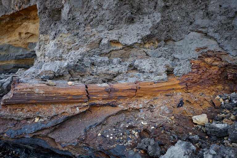
The popular name—Forest-Bed—derives from Arderon’s description of submerged tree trunks and roots along the Norfolk coast, but today this is considered a misnomer. In the 19th century, there was much discussion as to whether the submerged trees formed part of the Forest-Bed or not. The current scholarly consensus is that these tree did not grow in the Forest-Bed sediments, but were drifted there by water and deposited in the strata, creating the impression that they had grown out of the sediments. It is now thought that they actually grew on the steep banks of an ancient river, the Ancaster, whose estuarine sediments comprise the Cromer Forest Bed:
As the question whether the tree-stumps are or are not rooted in the “Forest- bed” has been much discussed, it will be advisable to give a brief outline of the reasons which have led me to the latter conclusion ... It is remarkable that a large proportion of lop-sided stumps (i,e. stumps with all the roots growing from one side) are found. This would be inexplicable were the general description correct of the way the trees grew on the level surface of the pre-glacial soil; but when we consider them to have been drifted, it is just what might be expected, for many would have grown out of the steep river-bank, and been undermined and carried away by the current (Reid 22-23)
Lithostratigraphy
The stratigraphy of the Cromer Forest Bed has been revised several times since the geological significance of the formation was first revealed more than two hundred years ago (Reid 20-21). Initially, they were thought to be preglacial drifts, deposited during or even before the Pliocene Epoch, several million years prior to the onset of the Pleistocene Ice Age. In the 1950s and ’60s, this view was revised and the deposits were reclassified as interglacial drifts, laid down during the Cromerian Stage. The current model, however, is considerably more complex than this.
Chalk lies under almost all of Norfolk and its top is an erosional surface. In North Norfolk a series of Early and Middle Pleistocene marine and freshwater deposits lie on this surface and are usually capped by tills and outwash sands and gravels of the Anglian glaciation (MIS 12). The marine deposits in this sandwich are known as the Wroxham Crag (formerly the Weybourne Crag) and the freshwater deposits are collective called the Cromer Forest-bed Formation (CF-bF) which was sometimes known as the Norfolk Forest-bed in the past. The name is a misnomer as there are no trees in situ but the remains of logs and stumps are often encountered and the Forest-bed name has stuck since antiquity. (The Norfolk Project)
The current consensus among conventional geologists is that the Cromer Forest Bed was deposited over a lengthy period of time—between 2 Mya and 0.5 Mya—by an ancient river that flowed from the Pennines to the North Sea:
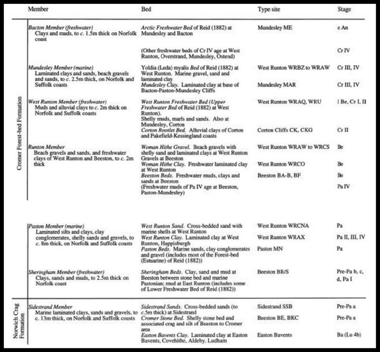
The formation encompasses the fluvial, lacustrine and organic deposits of the postulated ‛Ancaster River’, which is believed to have flowed from the Pennines to the North Sea along a line corresponding approximately to the present north coast of Norfolk. Four members are recognised in north Norfolk coastal sections. The Sheringham Member (lowest member) comprises freshwater organic mud, clay and sand. The Runton Member includes laminated freshwater silty clay. The West Runton Member comprises layers of alluvial clay and organic freshwater mud. The Bacton Member (highest Member) comprises clay and organic mud.
Definition of Lower Boundary: Rests disconformably on Chalk or on Wroxham Crag Formation, and interdigitates with Wroxham Crag Formation. The interdigitated succession is as follows, from top down: Bacton Member (Cromer Forest-bed Formation); Mundesley Member (Wroxham Crag Formation); Runton Member (upper part, Woman Hithe Gravel of Reid, 1882; Wroxham Crag Formation); Runton Member (lower part, Woman Hithe Clay of Reid, 1882; Cromer Forest-bed Formation); Paston Member (Wroxham Crag Formation); Sheringham Member (Cromer Forest-bed Formation); Sidestrand Member (Wroxham Crag Formation).
Definition of Upper Boundary: Overlain by Middle Pleistocene glacial deposits (Happisburgh Glacigenic, Lowestoft, Sheringham Cliffs and Briton’s Lane formations).
Thickness: About 6 m.
(The BGS Lexicon of Named Rock Units)

There are, therefore, seven distinct strata between the Sidestrand Member of the Wroxham Crag Formation and the Middle Pleistocene Glacial Deposits. Four of these comprise the Cromer Forest Bed, and between these are three strata of the Wroxham Crag Formation. The latter are believed to be of marine origin:
The Wroxham Crag Formation is a stratigraphic term recently introduced to describe quartz-bearing shallow marine deposits in northern East Anglia that outcrop between the Norwich Crag Formation and the Lowestoft Formation. (Lee et al 3)
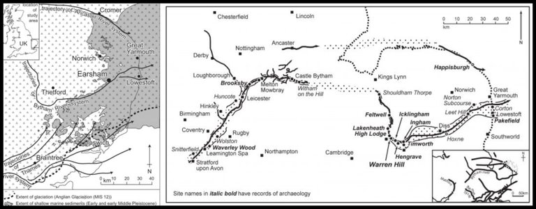
The sequence of events recorded by this lithostratigraphy, therefore, implies that the northern part of East Anglia was alternately inundated by the sea and watered by the Ancaster River. The Wroxham Crag Formation deposits were laid down when the area was under the North Sea, and the Cromer Forest Bed deposits were laid down when the area formed the estuary of the Ancaster River:
The Ancaster River is inferred to have drained a catchment extending from the Pennines and East Midlands, across Lincolnshire and the present offshore area between Lincolnshire and north Norfolk during the Early and Middle Pleistocene (Rose 2001). No deposits of the Ancaster River have been formally recognised however it is likely that some of the fluvial sensu stricto, elements of the Cromer Forest-bed Formation of north Norfolk including the Cromer Forest-bed may be deposits of this river system. In the absence of firm, direct evidence, the existence of the Ancaster River has been inferred based upon the reconstructed form of the pre-glacial land surface (Clayton, 2000), and the presence of northern-derived clast lithologies. (Lee et al 2-3)
This makes some sense if all seven strata were deposited during the Cromerian Interglacial, which is conventionally dated to 0.8-0.5 Mya. But how could some of these deposits be as old as 2 My? Several glacial periods occurred between 2 Mya and 0.8 Mya (namely, the Pre-Pastonian or Baventian Stage and the Beestonian Stage) which are not represented in the Forest-Bed Formation. The current explanation of this anomaly is that the formation has significant gaps and unconformities:
In the most recent and complete stratigraphical study, West (1980) has divided the CF-bF into a succession of chronostratigraphic stages. The earliest deposits, resting on chalk bedrock, are assigned to the Pre-Pastonian (Baventian) Cold Stage, succeeded by the Pastonian Temperate Stage, Beestonian Cold Stage, Cromerian Interglacial Stage, and Anglian Cold Stage. The occurrence of major gaps in the succession, particularly within the Beestonian Stage, is now recognised (West 1980; Gibbard et al. 1990). (Lister 26)
Unfortunately, Richard Gilbert West’s 1980 analysis, which is now accepted as the definitive interpretation of the lithostratigraphy, is not available online.

William Bourke Wright
Velikovsky’s principal source for this section is the Irish geologist William Bourke Wright. W B Wright was born in Dublin in 1876 and studied at Trinity College. His initial interests were in the field of mathematics. These led him to investigate James Croll’s theory that ice ages were caused by variations in the eccentricity of the Earth’s orbit and the precession of the equinoxes. This sparked an interest in geology which was only extinguished by his death.
In 1901, he joined the Geological Survey of Great Britain and Ireland. Over the next decade or two, he worked as a geological surveyor in Ireland, England and Scotland. After the Great War, he devoted the last twenty years of his career to a variety of tasks, such as re-mapping the coalfields of Ballycastle and Lancashire, and running the Geological Survey’s office in Manchester. He also found time to write, and several of his publications disseminated his views to a broader audience:
Geology is most indebted to Wright for his well-known Quaternary Ice Age, published in 1914, which was destined to replace James Geikie’s Great Ice Age, the glacial guide of previous generations. In this admirable work, Wright presented in an eminently readable form a digest of modern thought as expressed in the bewildering and often inaccessible literature of glacial geology. It dealt with the glaciers and their activities and with the various phases through which the planet passed during the Ice Age. In its most original part, it elaborated a theory, subsequently termed the isokinetic theory, which sought to explain the puzzling variations of the sea-level during Quaternary times. It ascribed them to the interaction of two forces, the first a partial locking up of the sea-water in the ice-sheets, the second the slow isostatic movements of the land which the ice imposed by its load. (Charlesworth 252)
Wright’s Isokinetic Theory was a reworking of the Isostatic Theory of Scottish geologist Thomas Jamieson, to whom Wright dedicated The Quaternary Ice Age. However, he rejected Croll’s theory of ice ages, which had sparked his initial interest in geology:
An almost fatal objection to Croll’s famous theory is the date it assigns to the end of the Ice Age, which it places some 80,000 years back. If, as De Geer seems to have clearly established (see p. 343), the ice-margin retreated north past Stockholm only about 9000 years ago, this practically excludes any possibility of a connexion between glaciation and changes in the eccentricity of the earth’s orbit. (Wright 451)
William Bourke Wright died of a heart attack on 11 October 1939, at the age of just 63.
The Quaternary Ice Age was first published in 1914, but Wright revised the book towards the end of his career. It is this second edition of 1937 that Velikovsky cites. Unfortunately, only the first edition is available online—HathiTrust—and if your location is outside the United States, you will have to use a VPN to gain full access.

Richard Foster Flint
Velikovsky introduces his discussion of the Norfolk Forest-Bed with a quotation from the American geologist Richard Foster Flint. Flint’s Glacial Geology and the Pleistocene Epoch was cited by Velikovsky earlier in Chapter 2 in connection with erratic boulders. Although the Professor of Geology in Yale University was a gradualist, Velikovsky is happy to quote him on the complexity of Britain’s glacial stratigraphy. Significantly, however, he omits the final clause, which weakens his case:
The Pleistocene stratigraphy of Britain is peculiarly complicated for two reasons. First, Britain was glaciated both by the Scandinavian Ice Sheet and by local glaciers. Second, the local glaciers flowed outward not from a single center but from several, and the volumes of ice spreading from each varied from time to time. The result is complex interbedding of drift sheets derived from different sources which, fortunately, are rendered more distinct by virtue of the highly varied bedrock geology of Britain, making possible the extensive use of indicator stones.
When we add to these factors the additional complications imposed by thin drifts, scanty interglacial deposits, and the frequent presence in fossil-bearing beds of secondary fossils derived from the reworking of older horizons, we get a truly difficult overall problem.
The average thickness of the British drifts and the proportion of exposed sections revealing two or more drift sheets are certainly less than those obtainable in northern Germany. The explanation probably is that northern Germany lies in the outer, predominantly depositional zone of the Scandinavian Ice Sheet, whereas Britain, having its own glaciers, lost more by erosion than it gained by drift deposits, a net loss
rendered the more conspicuous because rise of sealevel has submerged large areas of glacial deposits off the present coasts of Britain. All in all, British glacial-stratigraphic research has encountered exceptional difficulties which, thanks to persistent and detailed study, are now being overcome. (Flint 337)
Velikovsky’s citation in the footnotes attributes this quotation to page 377 of Flint’s text, but the quotation actually comes from page 337. Is this a printer’s typographical error or did Velikovsky himself misread the page number? The error is also present in the 1965 edition of Earth in Upheaval published by the Dell Publishing Company (page 61).
Flint does briefly discuss the Cromer Forest-Bed in Glacial Geology and the Pleistocene Epoch:
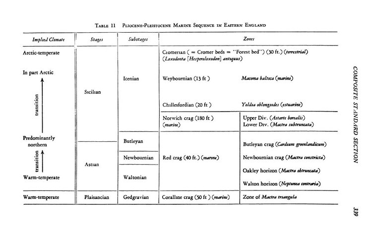
CROMER SEQUENCE. The uppermost unit shown in the accompanying table consists of the Cromer beds, separated from the horizon beneath them by a disconformity of unknown significance. This unit has three members, all of them terrestrial, representing conditions near the shore of an estuary. A basal clay-and-lignite member is overlain by the much-discussed “forest bed,” so called because it was once thought to include tree stumps in place. Actually it consists of lignite and inorganic sediments, inclosing transported stumps of trees and the transported teeth and bones of sixty species of mammals, birds, frogs, and snakes. The mammals include the straight-tusked elephant (Loxodonta [Hesperoloxodon] antiquus), Hippopotamus, and two species of rhinoceros, all of them suggesting temperate or warm-temperate climate.
Overlying the “forest bed” is a sand and clay member containing many land and fresh-water mollusks, land plants, and rodents. The implied climate is similar to that of the same region at the present time.
Between the Cromer sequence and the overlying till are a marine sand with both temperate and Arctic mollusks and, above it, fine alluvium with plants characteristic of the Arctic tundra. These two members have been thought of by some as the base of the Pleistocene. Viewed in a broad way the Cromer sequence and the beds immediately overlying it seem to indicate interglacial conditions terminating with the new approach of glaciation. (Flint 339-340)
Flint gives no source for any of this, but his allusion to sixty species of mammals, birds, frogs, and snakes is repeated by Velikovsky without citation. The five remaining citations in this section are all taken from the 1937 edition of Wright’s The Quaternary Age.
Fossils
The alternation of marine and littoral strata in the Cromer Sequence testifies to the mutability of the Earth’s climate during the Pleistocene. But on a timescale of 1.5 million years these changes do not necessarily require the geologist to embrace catastrophism. The repeated encroachments of the North Sea onto the coast of East Anglia and its subsequent withdrawals might just as easily be explained by a gradualist model of climate change. The same, however, cannot be said for the fossils that lie buried in these strata. Explaining the presence of these fossils without invoking catastrophism is challenging, to say the least.
Most of the large mammalian fossils have been recovered from the Forest Bed (Wright 86-87). These include the following species, several of which are now extinct (in italics) (Wright 88-89):
- Sabre-Toothed Tiger
- Wolf
- Fox
- Spotted Hyena
- Grizzly Bear
- Cave Bear
- Pine Marten
- Wolverine
- Eurasian Otter
- European Bison
- Muskox
- Mouflon
- Broad-Fronted Moose
- Dawkins’ Deer
- Roe Deer
- Red Deer
- Cervus (Nine Species of Extinct Deer)
- Hippopotamus
- Wild Boar
- Horse
- Stenon Zebra
- Etruscan Rhinoceros
- Rhinoceros megarhinus
- Straight-Tusked Elephant
- Southern Mammoth
- Woolly Mammoth
- European Water Vole
- Common Vole
- Red Field Vole
- Narrow-Headed Vole
- Arvicola intermedius
- Wood Mouse
- Eurasian Beaver
- Giant Beaver
- European Mole
- Common Shrew
- Pygmy White-Toothed Shrew
- Russian Desman
Nowhere in the world today can one find such a diverse range of mammalian species living side by side. The spotted hyena, for example, can only be found in sub-Saharan Africa, whereas the Eurasian beaver, European mole and European water vole are exclusive to Eurasia and are not found even as far south as the Mediterranean Sea. The muskox is an Arctic mammal, and the wolverine is now restricted to the Taiga and Tundra regions. The hippopotamus is exclusive to Africa.
Even Wright was surprised to find the remains of animals from such widely different habitats deposited in the same strata:
The list contains two exclusively northern species, species, the glutton [wolverine] and the musk-ox, the occurrence of which with the other animals is to be wondered at; the musk- ox indeed more so than the glutton, because the latter belongs to the carnivora, which have generally a great climatic range, and are limited more by want of food, competition, or human agency than by temperature. (Wright 90)
Even more surprising is the evidence provided by the remains of plants recovered from the Forest Bed:
Remains of 68 species of plants have been obtained by Mr. Reid from the Forest-bed. Two of these, the water-chestnut and the spruce-fir, do not appear to have belonged to the British flora since the glacial period. There is an absence of both Arctic and S. European plants, and the whole association indicates a climate and geographical conditions very similar to those of Norfolk at the present day. The sensitiveness of plants to range of temperature makes them especially trustworthy as indicators of climatic conditions, and renders this conclusion more valuable than any derived from the fauna. (Wright 90-91)
But, as Velikovsky points out, this floral evidence flatly contradicts that of the fauna. Wright concedes that the extensive fauna of the Forest Bed is indicative of continental conditions, the island of Great Britain being considered too small to have supported such a diversity of large mammals. He hypothesizes that perhaps Britain was not an island when the Forest Bed was laid down, but confesses his reluctance to date the opening of the Strait of Dover to the postglacial age. Today, the opening of the strait is ascribed to the postglacial age. But even if this point is conceded, it still does not explain how animals of widely differing habitats could have dwelt together in this small region.
And a similar contradiction can be found in the strata above the Forest Bed:
Above the Forest-bed and below the oldest known glacial deposit of Norfolk occur two beds:
(2) A freshwater or flood deposit with Arctic plants.
(1) A marine bed characterised by Leda myalis [an Arctic mollusk].The lower of these, the Leda myalis bed, consists of fine false-bedded loamy sand, only slightly fossiliferous, but containing Leda myalis, elsewhere unknown on this side of the Atlantic, Astarte borealis and other shells in the position of life, with both valves united. The species mentioned are arctic, but, as the bed seems in other places to contain Ostrea edulis, which requires a temperate sea, the evidence is conflicting as to climate. (Wright 92)
In Velikovsky’s opinion, there is only one reasonable conclusion to draw:
It would appear that this agglomeration was brought together by a moving force that rushed overland, left in its wake marine sand and deep-water creatures, swept animals and trees from the south to the north, and then, turning from the polar regions back toward the warm regions, mixed its burden of arctic plants and animals in the same sediment where it had left those from the south. Animals and plants of land and sea from various parts of the world were thrown together, one group upon another, by some elemental force that could not have been an overflowing river. Also bones of animals already extinct in earlier epochs were carried out of their beds and thrown into the jumble. (Velikovsky 53-54)
Velikovsky sees the Cromer Forest Bed as further evidence of recent catastrophism, which is in agreement with the evidence from the Arctic that he reviewed in the preceding chapter:
The finding of warm-climate animals and plants in polar regions, coral and palms in the Arctic Circle, presents these alternatives: either these animals and plants lived there at some time in the past or they were brought there by tidal waves. In some cases the first is true, as where stumps of trees (palms) are found in situ. In other cases the second is true, as where, in one and the same deposit, animals and plants from sea and land, from south and north, are found in a medley. But in both cases one thing is apparent: such changes could not have occurred unless the terrestrial globe veered from its path, either because of a disturbance in the speed of rotation or because of a shift in the astronomical or geographical position of the terrestrial axis.
In many cases it can be shown that southern plants grew in the north; either the geographical position of the pole and the latitudes or the inclination of the axis must have changed since then. In many other cases it can be shown that a marine irruption threw into one deposit living creatures from the tropics and from the Arctic; the change must have been sudden, instantaneous. We have both kinds of cases. Consequently there must have been changes in the position of the axis, and they must have been sudden. (Velikovsky 54)
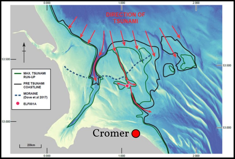
Scientists do believe that Doggerland and the Norfolk coast were devastated by a megatsunami around 6200 BCE, but that was small potatoes compared to the global upheaval Velikovsky is postulating.
And that’s a good place to stop.
References
- William Arderon, Extract of a Letter from Mr. William Arderon, F. R. S. to Mr. Henry Baker, F. R. S. Containing Observations on the Precipices or Cliffs on the North-East Sea-Coast of the Country of Norfolk, _Philosophical Transactions, Volume 44, Issue 481, Pages 275-284, The Royal Society, London (1746)
- John Kaye Charlesworth, Obituary: William Bourke Wright (1876-1939), The Irish Naturalists' Journal, Volume 7, Number 9, Pages 250-253, Irish Naturalists’ Journal Ltd, Dublin (1940)
- Richard Foster Flint, Glacial Geology and the Pleistocene Epoch, John Wiley & Sons, Inc, New York (1947)
- J R Lee et al, Pre-Devensian Lithostratigraphy of Shallow Marine, Fluvial and Glacial Sediments in Northern East Anglia, in I Candy, J R Lee, A M Harrison (editors), Quaternary of Northern East Anglia - Field Guide, Quaternary Research Association, Edinburgh (2008)
- Adrian Lister, The Stratigraphical Interpretation of Large Mammal Remains from the Cromer Forest-Bed Formation, in Turner (editor), The Early Middle Pleistocene in Europe, Pages 25-44, Balkema, Rotterdam (1996)
- Clement Reid, The Geology of the Country Around Cromer, The Geological Survey, London (1882)
- Immanuel Velikovsky, Earth in Upheaval, Dell Publishing Co, Inc, New York (1965)
- Immanuel Velikovsky, Earth in Upheaval, Pocket Books, Simon & Schuster, New York (1955, 1977)
- Richard Gilbert West, The Pre-Glacial Pleistocene of the Norfolk and Suffolk Coasts, Cambridge University Press, Cambridge (1980)
- William Bourke Wright, The Quaternary Ice Age, Macmillan and Co, Limited, London (1914)
Image Credits
- Cromer Forest Bed (West Runton Cliffs, Norfolk): Stavros1 (photographer), Public Domain
- Map of East Anglia: Antony John Sutcliffe & Kazimierz Kowalski, Pleistocene Rodents of the British Isles, Bulletin of the British Museum (Natural History) Geology, Volume 27, Number 2, Pages 31-147, London (1976), Figure 2, Page 46, Public Domain
- Fossil Tree Trunk in Cromer Forest Bed: © Colin (photographer), Creative Commons License
- Lithostratigraphy of the Cromer Forest Bed: © R G West, The Early Middle Pleistocene in Europe, Taylor & Francis, Abingdon, Oxfordshire (1996), Table 1, Fair Use
- British Pleistocene Sequence: Antony John Sutcliffe & Kazimierz Kowalski, Pleistocene Rodents of the British Isles, Bulletin of the British Museum (Natural History) Geology, Volume 27, Number 2, Pages 31-147, London (1976), Table 1, Page 41, Public Domain
- Ancaster and Bytham River Systems (Left): © 2017 The Geologists’ Association, Fair Use
- Ancaster and Bytham River Systems (Right): © The Geologists’ Association, Fair Use
- Richard Gilbert Wright: © University of Cambridge, Fair Use
- William Bourke Wright: The Irish Naturalists’ Journal, Volume 7, Number 9, Pages 250-253, Irish Naturalists’ Journal Ltd, Dublin (1940), Public Domain
- Richard Foster Flint: Copyright Unknown, Fair Use
- R F Flint’s Lithostratigraphy of the Cromer Sequence: Richard Foster Flint, Glacial Geology and the Pleistocene Epoch, Table 11, Page 339, John Wiley & Sons, Inc, New York (1947), Public Domain
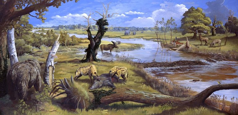
- Artist’s Depiction of the Ancaster Valley 0.65 Mya: © Nick Arber (artist), Fair Use
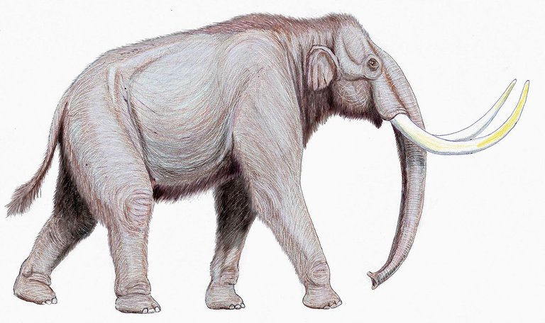
- Steppe Mammoth (Mammuthus trogontherii): © Dmitry Bogdanov, Creative Commons License
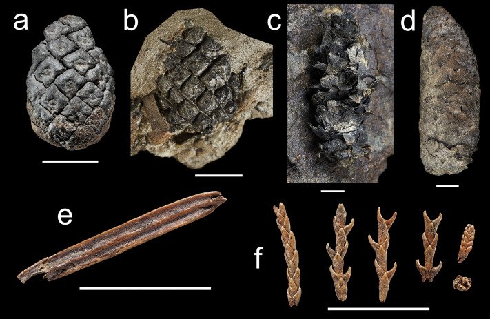
- Cromer Forest Bed Fossil Conifers (Happisburgh): © Aljos Farnon et al, Early Pleistocene Conifer Macrofossils from Happisburgh, Norfolk, UK, and Their Environmental Implications for Early Hominin Occupation, Quaternary Science Reviews, Volume 232, Elsevier (2020), Fair Use
- Postglacial Megatsunami off the Norfolk Coast: © University of Bradford, Fair Use
.JPG)