What data collection is important for petroleum well drilling planning?
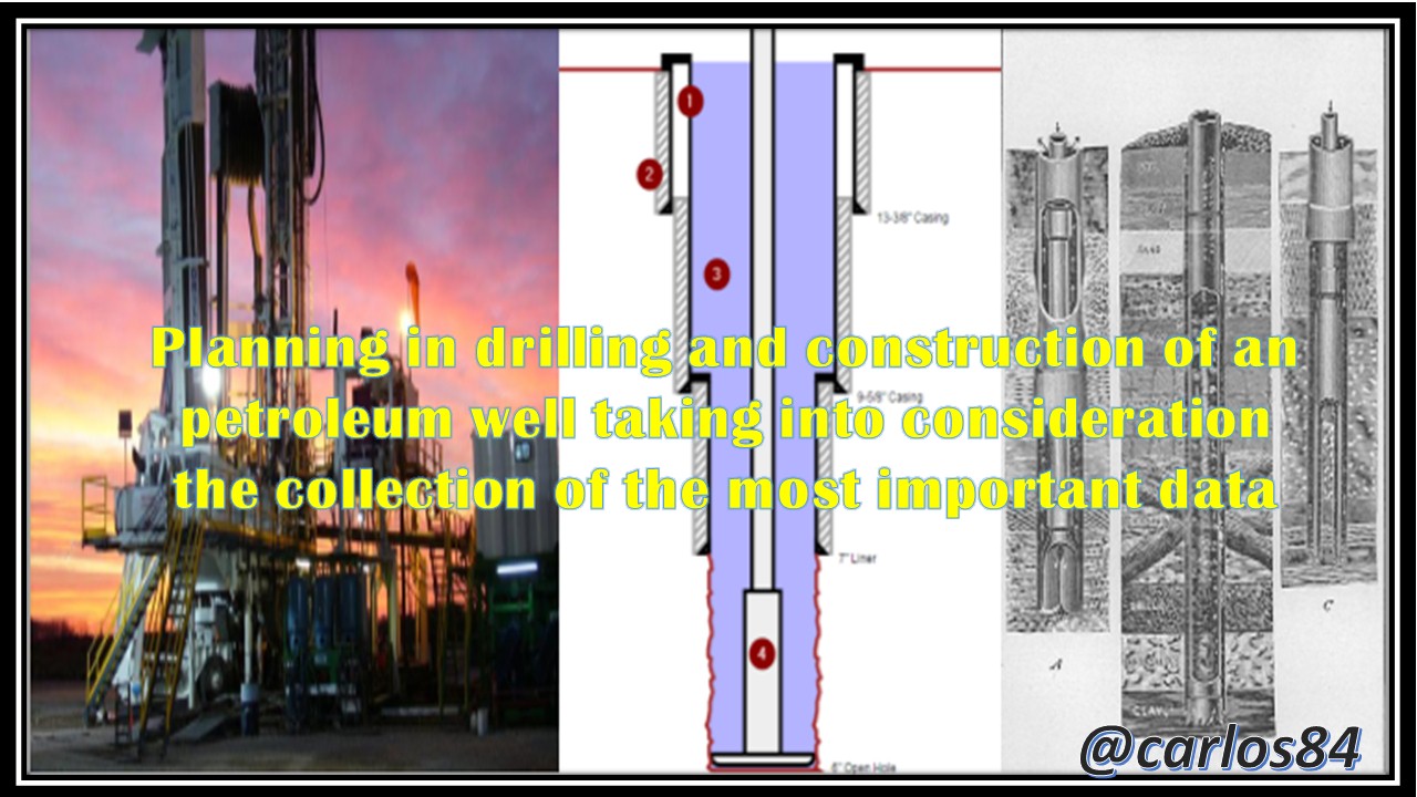
In this opportunity I will present to all of you this post dedicated to explain what are the most relevant data to be taken into account at the time of planning the construction and drilling of an oil well.
Introduction
One of the most relevant aspects for engineering is the planning in the drilling and construction of an oil well, that is why in any design it is important to include certain characteristics that are expected at the time of drilling and constructing the well, also must be taken into account in the planning the future problems that may arise.
The data that must be taken into account at the time of designing the planning of a well are necessary because if in a given case these data are not taken into account then the planning will not be successful once the construction and drilling operations of an oil well are started.
Rather than considering such data, it is important for the drilling engineer to initially look for different types of data ranging from previous equipment characteristics to well log information and even important geological information.
How is the selection of future wells to be drilled carried out?
As I mentioned before it is the drilling engineer who takes an important part in the planning of the well, however it is not always the drilling engineer who is responsible for selecting the place where the oil wells will be drilled, this is important to know because the drilling engineer must work together with the geologist, these two professionals are responsible for selecting the place to drill the oil wells, perhaps many of you reading this post are wondering:
Why should the geologist and the drilling engineer be in charge of selecting the drilling area?
There are many reasons to explain why it should not be only the drilling engineer who should take responsibility for selecting the drilling area, however I will try to explain some points that I consider important to explain these reasons:
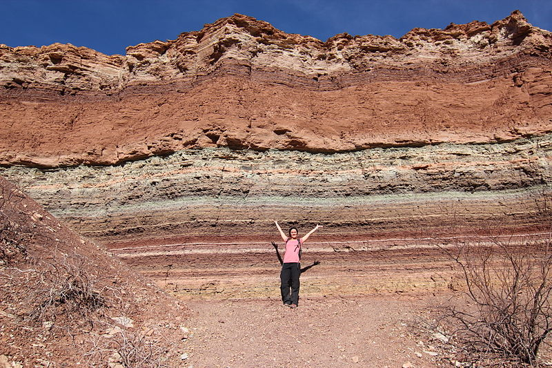
[1] When selecting the drilling area to construct an petroleum well, it is necessary to estimate how the geology found in the subsoil will be, so that in this way a defense can be found against drilling problems that may arise in the drilling of the well, these estimates can only be achieved satisfactorily thanks to the knowledge of the geologist as that professional expert in knowing how the geological strata are deposited and how the pressure of these hydrocarbons accumulated in its formation.
.jpg)
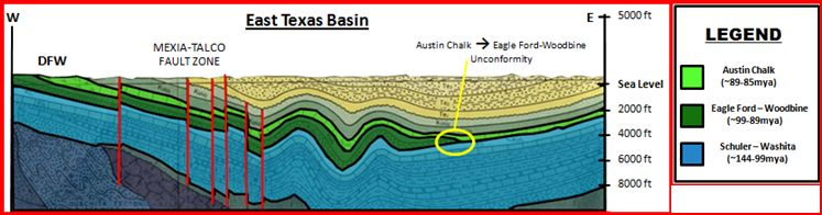
[2] Another reason why it is so essential for the geologist to participate in the selection of the drilling, area is because the geologist can define certain geological structures such as structural faults, this early discovery of these types of geological structures allows, in addition to selecting the drilling site, to apply a drilling plan that adapts to the conditions of these structural faults.

[3] From my personal and field experience, I could tell you that the geologist is not only important when selecting the drilling area, but it is also important to continue teaming up with the drilling engineer, because together with the drilling engineer can identify certain geological irregularities during the drilling process such as an abnormal pressure zone, stratigraphic set that represents a highly porous and permeable zone, in short you can get to identify geological zones that can cause problems and stop the continuity of drilling.
What kind of geological information can be handled in drilling?
Entre los datos geológicos que puede recibir el equipo de perforación por parte del equipo geológico destacan muchos datos, sin embargo mi intención en este post es colocar algunos ejemplos alusivos para que muchos de los que leen este contenido se hagan una idea del tipo de datos que se manejan en este intercambio de conocimiento entre los expertos en geología y los ingenieros en perforación.
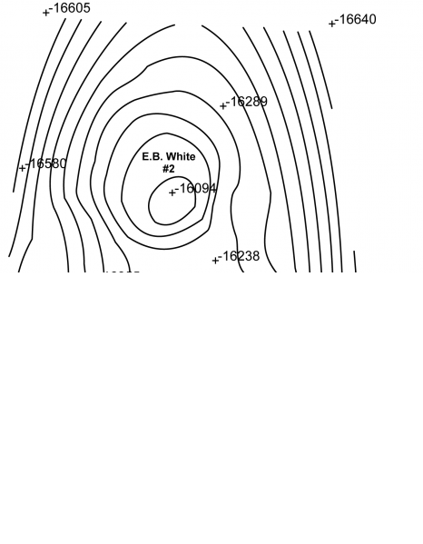
Un ejemplo de esto está cuando el equipo de geología ha encontrado un posible reservorio de hidrocarburo en un área determinada, para ello el equipo de geología realiza un mapa de contorno en donde les puede mostrar al equipo de perforación cuales pueden llegar hacer los puntos claves para perforar los pozos de petróleo que son prospectos en base a la estructura que arroja el mapa contorno.
In the image above you can see an example of a contour map, which can be delivered by the geological team to the drilling team, it is necessary that the drilling team can get the structure or producing reservoir, the important thing about this reading is not so much area location but depth location, as can be seen in the image of the contour map the producing zone is E.B. White #2 and is at an estimated depth of 16094 feet.
What data sources exist for planning in the drilling and construction of an oil well?
The more data the drilling engineer can count on, the better, however it is important that the drilling engineer has defined what data he can immediately count on when planning the drilling and construction of an oil well.
The types of data most commonly used by the drilling engineer are the following:
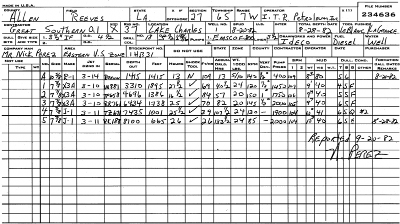
Bit records
Si los pozos que se van a perforar están dentro del mismo yacimiento productor, entonces es propicio tomar el registro de las barrenas que fueron empleadas en la perforación de pozos vecinos.
A continuación les voy a mostrar un ejemplo de un registro de barrenas y de esta forma identifiquemos los elementos que se toman en cuenta en este registro de barrenas.
This bit log can be a very important part when planning the well, since the information in the header of the bit log can provide us with information for the construction of the new well, such as: the contractor company and the operator of the bits used in the neighboring wells, characteristics of the tubing string such as drill collars, drill pipe, among others.
Conclusion
Performing a compilation of the data that I have explained in this post, including other data that are also relevant such as those that are referred to mud logs can provide us with the necessary tools for a real-time analysis of when the drilling of the well is being executed.
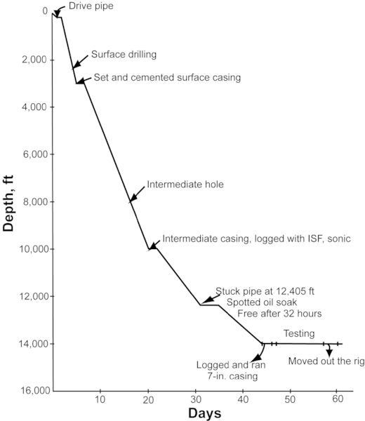
The above mentioned is applicable in well drilling, since the personnel in charge of drilling wells must make daily reports in which graphs of length drilled vs. days spent to achieve such progress are prepared and filed. When the length drilled is estimated and divided by the elapsed time a rate of change known as rate of penetration (ROP) can be calculated, to calculate the average rate of penetration it is necessary that the depth and time data be taken from the next log:
If these logs of depth drilled vs. time are analyzed, several benefits can be achieved in the development of the drilling program that concerns the planning in the drilling and construction of an oil well, for example, an estimate of the drilling times of the well to be drilled can be made based on the logs obtained from neighboring wells, at the same time the estimate of drilling times can give us an indication of the drilling costs that can be obtained in the drilling and construction of the candidate well to be drilled.
The important thing about the data that can be collected from other neighboring wells for the planning in the drilling and construction of a well in development is that it can give us an indication of four key factors that are:
Time to be spent in the drilling and construction of the well.
Estimated costs in the drilling and construction of the well.
Possible equipment to be used in the drilling and construction of the well.
The possibility of being able to attack and solve the possible operational problems that may arise in the drilling and construction of the well.
References
Data analysis in well planning
Well Planning Software. Halliburton. PDF
Embedded well planning in the SKUA-GOCAD modeling environment
Thanks for your contribution to the STEMsocial community. Feel free to join us on discord to get to know the rest of us!
Please consider supporting our funding proposal, approving our witness (@stem.witness) or delegating to the @stemsocial account (for some ROI).
Please consider using the STEMsocial app app and including @stemsocial as a beneficiary to get a stronger support.
Thank you for your support to the stemsocial team. Regards