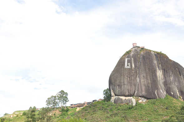
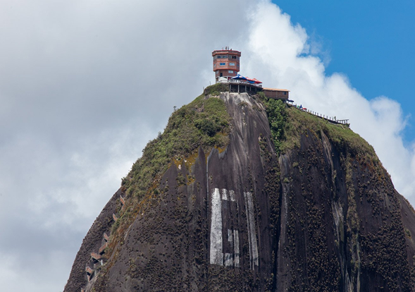
[ENG] "La Roca el Peñol" in Guatapé, Medellín, Colombia [ESP] “La Roca el Peñol” en Guatapé, Medellín, Colombia
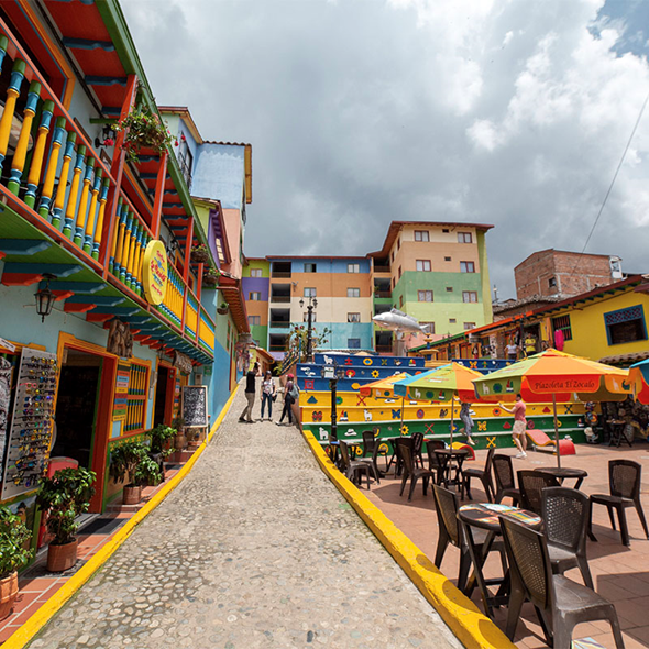
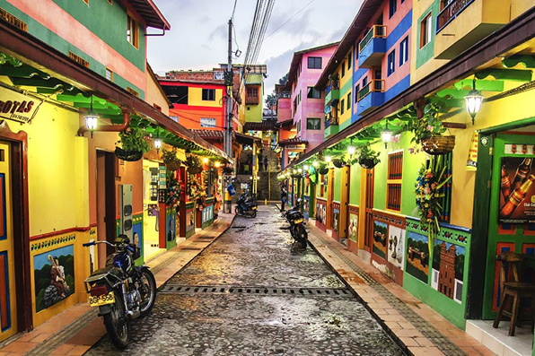
Dear friends of the great HIVE community, today I am going to share with you a series of photos taken by my brother-in-law Alfonso, on a family trip to “La Roca el Peñol”, which is accompanied by a brief description of both the town of Guatapé and the “Roca el Peñol ”, located in Medellín, in the Republic of Colombia. I am sorry that I cannot show you family photos of the town, but I have chosen two photos from the internet to give you an idea of the beauty of this rural Colombian town, which was partially displaced from its original place, in 1970, by the construction of the complex Medellín hydroelectric plant. The rest of the photos were taken by my brother-in-law on a recent visit to the Rock.
Guatapé, originally called "Site of Our Lady of Carmen de la Cexa (eyebrow) of Guatapé", then in the twentieth century it was called "Ceja de Guatapé", until reaching the name by which it is known today "Guatapé”. This rural town was a territory inhabited by aborigines and they called it Guatapé because of the brow shape that the mountain range has; It was, according to historians, the place where honors were paid to the Lord of Guatapé, who is supposed to protect and organize the land at those times.
The place is currently a municipality in Colombia at 1925 meters above sea level, with a temperate climate that ranges between 13 and 22 degrees Celsius. Located 75 kilometers from the city of Medellín, with a population of just over eight thousand inhabitants, which has gained worldwide fame thanks to its baseboards and for having in its bosom the “Roca el Peñol” one of the great and best viewpoints of the country.
Guatapé reminds us Venezuelans of the city of Puerto Cabello with its two-story houses with wooden balconies, painted in bright colors and its cobbled streets. But what distinguishes this small, such a beautiful town, are its baseboards, paintings and drawings in high relief that adorn the houses. In these plinths you can relive the history, customs, trades and nature of the place.
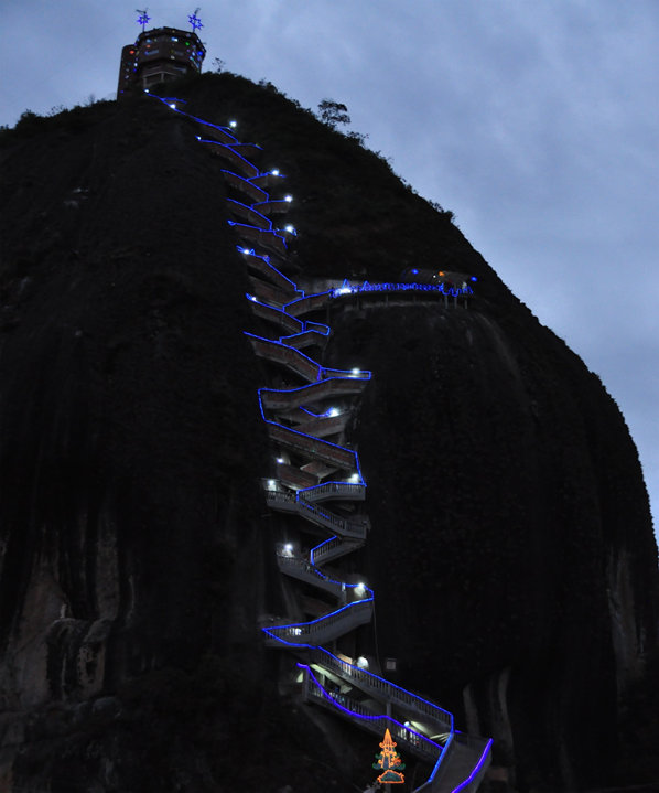
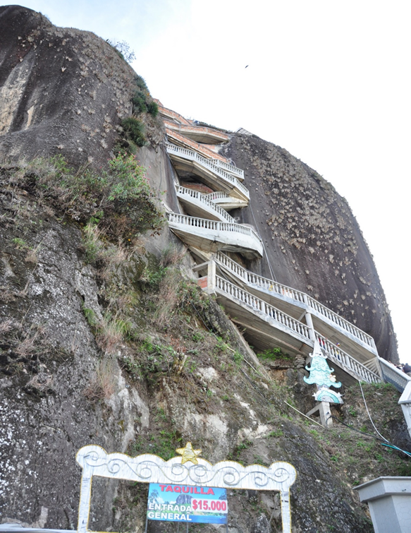
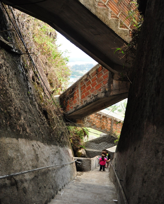
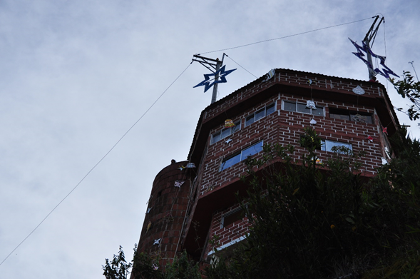
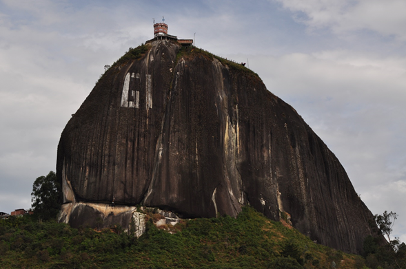
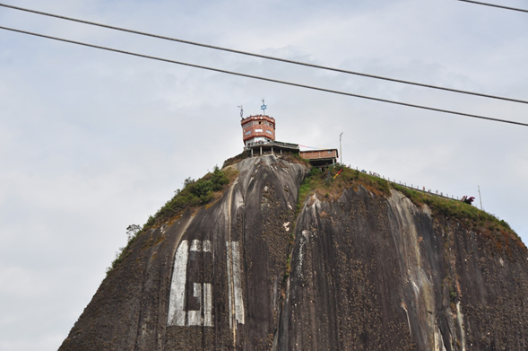
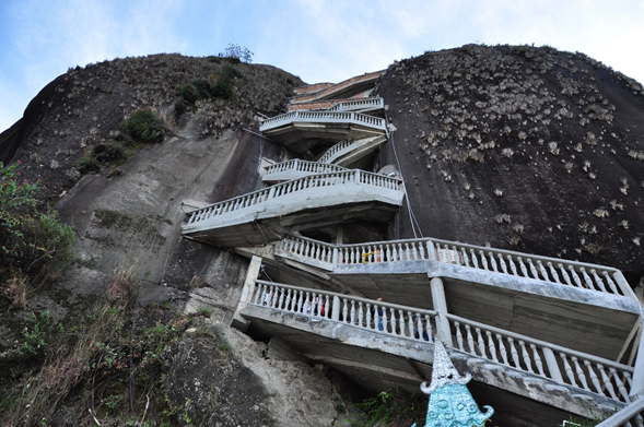
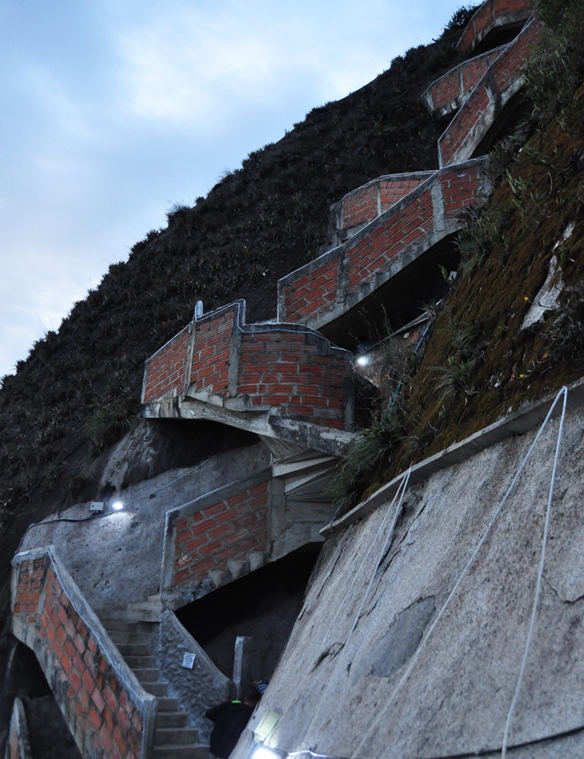
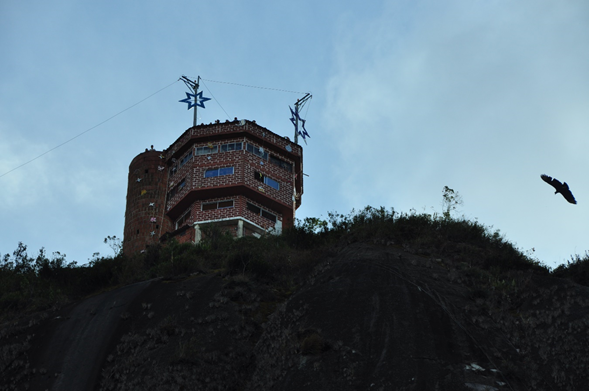
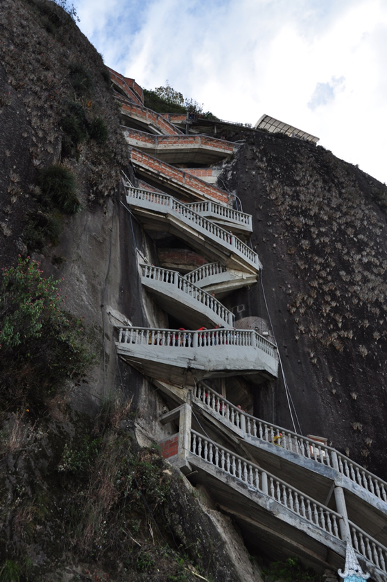
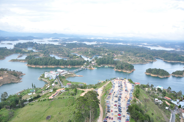
Going to Guatapé forces the visitor to know the "Peñón de Guatapé", Colombian cultural heritage, also known as "La Piedra del Peñol" which is a natural monolith, whose weight is estimated at more than 600 million tons, a volume of about 22 million cubic meters, made up mainly of quartz, feldspar and mica, with about 220 meters high and 100 meters in diameter, the top of which is reached by climbing its 702 steps, built on one side of the rock.
It is very possible that it was a sacred place for the pre-Hispanic indigenous culture of the Tahamíes who lived in the region. Certain legends are known about the Rock, among which the most famous is that a devil tried to take it away several times, the sample of which is the great crack that it has at one of its ends and that, at present, is covered by some wooden steps. The truth is that that crack served three neighbors who came up with wooden wedges that embedded in the natural crack that the stone has, the same one that is fabled is the crack produced by a devil. This wooden staircase was reinforced and remained standing until the 70s of the last century, when it was reinforced with concrete. The GI that can be seen painted on the rock was the attempt to place the name of the town, which was stopped by the local authorities, when the letter U was started, remaining there to be erased one day.
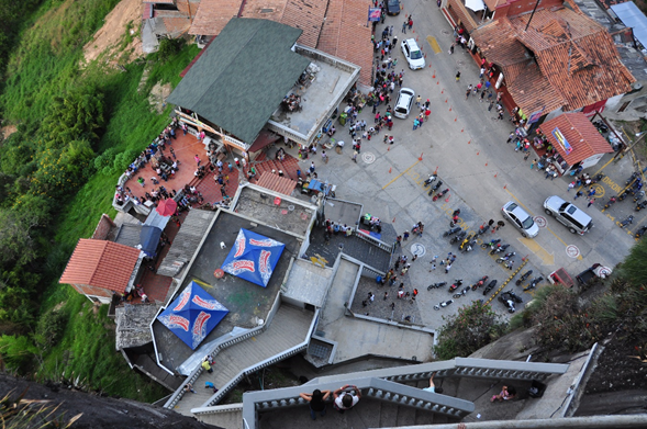
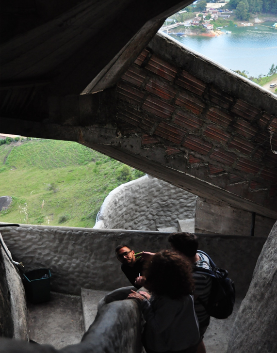
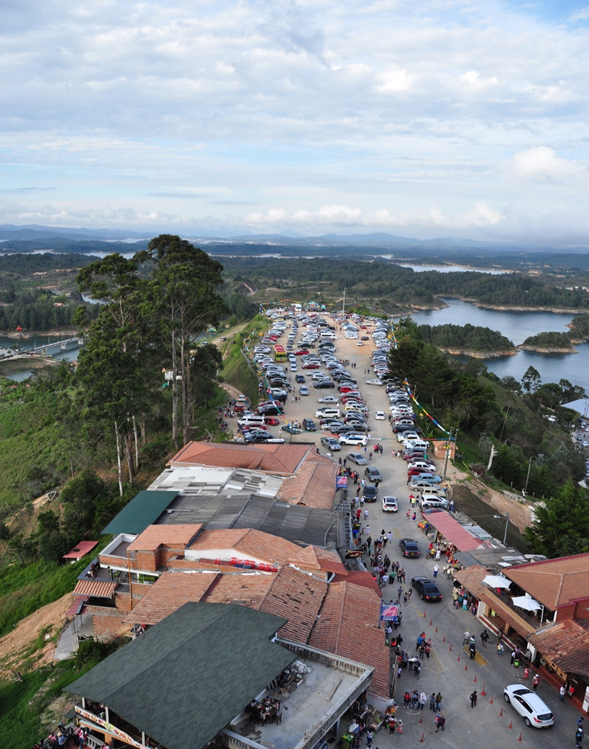
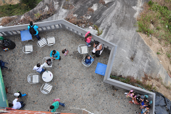
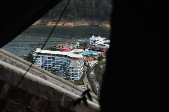
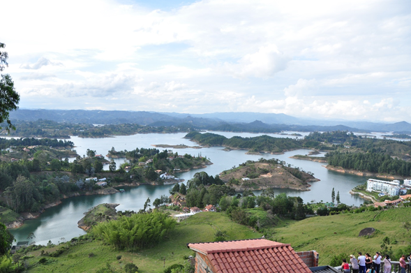
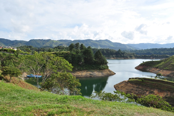
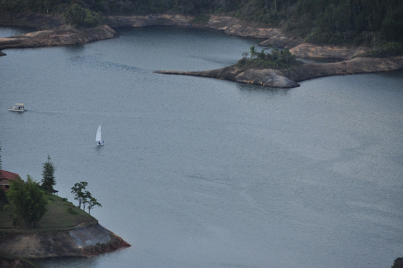
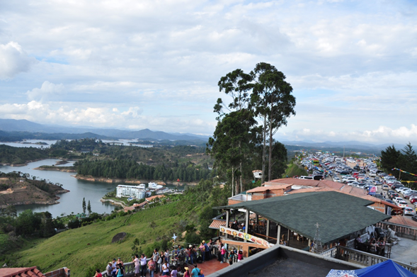
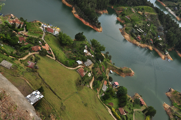
Once at the top of the rock, you can enjoy 360-degree panoramic views of the town, the surroundings and the reservoir of more than 2,200 hectares, where it is possible to distinguish the islands of unparalleled greenery and, for those who like to history, the old location of the town can be remembered by means of a cross that emerges from the water and that serves as a symbol of the original place. It is also possible to appreciate, in the food area, a series of handicrafts and typical sweets of the Paisa culture that can be purchased at reasonable prices, before starting the descent.
References:
*Tobón Aristizábal, Juan F.: Guatapé, un nombre que dejó pedazos en el camino. https://mioriente.com/historia-detras-de-un-nombre/guatape-nombre-dejo-pedazos-camino.html
*Guatapé y Piedra del Peñol: https://colombia.travel/es/medellin/guatape-y-piedra-del-penol
Estimados amigos de la gran comunidad HIVE, hoy voy a compartir con ustedes una serie de fotos tomadas por mi cuñado Alfonso, en un viaje familiar a esta localidad, la cual va acompañada de una breve descripción tanto del pueblo de Guatapé como de la “Roca el Peñol”, ubicados en Medellín, en la República de Colombia. Lamento que no pueda mostrarles fotos familiares del pueblo, pero he escogido dos fotos de internet para que se den una idea de la belleza de este pueblo rural colombiano, el cual fue desplazado parcialmente de su lugar original, en 1970, por la construcción del complejo hidroeléctrico de Medellín. El resto de las fotos fueron tomadas por mi cuñado en una visita recién a la Roca.
Guatapé, originalmente llamado “Sitio de Nuestra Señora del Carmen de la Cexa (ceja) de Guatapé”, luego en el siglo XX pasó a ser llamado “Ceja de Guatapé”, hasta llegar al nombre con el que se conoce en la actualidad “Guatapé”. Este pueblo rural era un territorio habitado por aborígenes y lo llamaban Guatapé por la forma de ceja que tiene la cordillera; era, según los historiadores, el lugar donde se le rendía honores al Señor de Guatapé, quien se supone protegía y organizaba la tierra en aquellos tiempos.
El lugar es, en la actualidad, un municipio de Colombia a 1925 metros sobre el nivel del mar, con un clima templado que oscila entre 13 y 22 grados Celsius. Ubicado a 75 kilómetros de la ciudad de Medellín, con una población de poco más de ocho mil habitantes, que ha ganado fama mundial gracias a sus zócalos y por tener en su seno la “Roca el Peñol” uno de los grandes y mejores miradores del país.
Guatapé nos recuerda, a los venezolanos, la ciudad de Puerto Cabello con sus casas de dos pisos con balcones de madera, pintadas en colores llamativos y sus calles empedradas. Pero lo que distingue a este pequeño, cuan bello pueblo, son sus zócalos, pinturas y dibujos en alto relieve que adornan las casas. En estos zócalos se puede revivir la historia, costumbres, oficios y naturaleza del lugar.
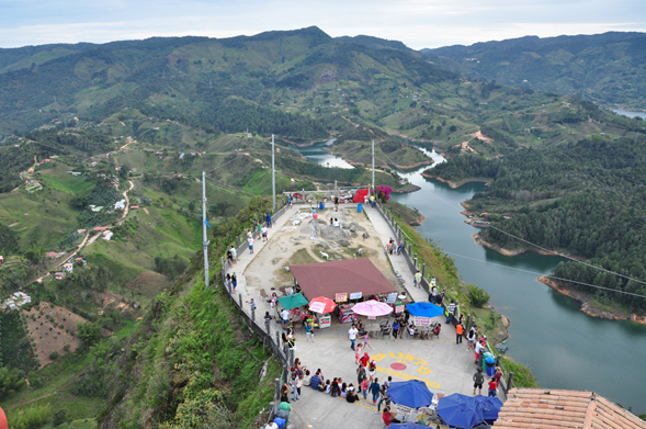
Ir a Guatapé obliga al visitante a conocer el “Peñón de Guatapé”, patrimonio cultural colombiano, conocido también como “La Piedra del Peñol” que es un monolito natural, cuyo peso está estimado en más de 600 millones de toneladas, un volumen de unos 22 millones de metros cúbicos, conformada fundamentalmente por cuarzo, feldespato y mica, con unos 220 metros de altura y 100 metros de diámetro, a cuya cima se llega subiendo sus 702 escalones, construidos en uno de los laterales de la roca.
Es muy factible que haya sido un lugar sagrado para la cultura indígena prehispánica de los tahamíes que moraban en la región. Se conocen ciertas leyendas sobre la Roca, entre las cuales la mas famosa es que un diablo intentó llevársela varias veces, cuya muestra es la gran grieta que tiene en uno de sus extremos y que, en la actualidad, está tapada por unos escalones de madera. Lo cierto es que esa grieta le sirvió a tres vecinos que subieron con cuñas de madera que incrustaban en la grieta natural que tiene la piedra, la misma que se fabula es la grieta producida por un diablo. Esta escalera de madera fue reforzada y se mantuvo en pie hasta los años 70 del siglo pasado, cuando fue reforzada con concreto. La GI que se ve pintada sobre la roca fue el intento de colocar el nombre del pueblo, lo cual fue detenido por las autoridades locales, cuando se iniciaba la pintada de la letra U, quedando allí para que algún día sean borradas.
Una vez en el tope del peñón se puede disfrutar de panorámicas, de 360 grados, del pueblo, las cercanías y el embalse de más de 2200 hectáreas de extensión, donde es posible distinguir las islas de un verdor sin igual y, para quien guste de la historia, se puede rememorar la antigua ubicación del pueblo por medio de una cruz que emerge del agua y que sirve de símbolo del lugar original. También es posible apreciar, en la zona de comidas, una serie de artesanías y dulces típicos de la cultura paisa que se pueden adquirir a precios módicos, antes de iniciar el descenso.
Referencias:
*Tobón Aristizábal, Juan F.: Guatapé, un nombre que dejó pedazos en el camino. https://mioriente.com/historia-detras-de-un-nombre/guatape-nombre-dejo-pedazos-camino.html
*Guatapé y Piedra del Peñol: https://colombia.travel/es/medellin/guatape-y-piedra-del-penol
Congratulations, your post has been added to Pinmapple! 🎉🥳🍍
Did you know you have your own profile map?
And every post has their own map too!
Want to have your post on the map too?
Good morning pinmapple friends. Thank you for adding my post to your community.
Thank you for sharing this amazing post on HIVE!
Your content got selected by our fellow curator @priyanarc & you just received a little thank you via an upvote from our non-profit curation initiative!
You will be featured in one of our recurring curation compilations and on our pinterest boards! Both are aiming to offer you a stage to widen your audience within and outside of the DIY scene of hive.
Join the official DIYHub community on HIVE and show us more of your amazing work and feel free to connect with us and other DIYers via our discord server: https://discord.gg/mY5uCfQ !
If you want to support our goal to motivate other DIY/art/music/homesteading/... creators just delegate to us and earn 100% of your curation rewards!
Stay creative & hive on!
Good morning friends of diyhub, I thank the curator @priyanarc for giving me this recognition, as well as the upvote.
Welcome :)
Hello @besamu. There seem to be some format issues with your post's written text - they appear tiny, Please adjust. Thanks a lot!
Estimados amigos de aplusd, gracias por la observación. Me pareció extraño que las letras fueran tan pequeñas y no supe como resolver el problema, pues no había hecho nada fuera de lo normal. Buscaré ayuda para resolver el problema.
Dear aplusd friends, thanks for the observation. It seemed strange to me that the letters were so small and I did not know how to solve the problem, because I had not done anything out of the ordinary. I will seek help to solve the problem.
You didn't close off the < /sub > at the end. Please amend it, your post is barely readable, the fact you managed to get any upvotes at all is quite reamarkable
Hello livinguktaiwan. You do not know how much I thank you for pointing out the omission I made. I was looking for a technician to check my computer. Thank you. I think I can no longer solve the problem in this post. Maybe those who voted for me went to the trouble of using Zoom to enlarge the text.
You're welcome @besamu. You can edit your post and add the missing / back before the sub here : Foto de alfceli@)< sub ></ center >
Hello livinguktaiwan. Thanks again. Fortunately a young frend of mine helped me to solve the problem, that you just pointed out.
Hiya, @LivingUKTaiwan here, just swinging by to let you know that this post made it into our Honorable Mentions in Daily Travel Digest #1357.
Your post has been manually curated by the @pinmapple team. If you like what we're doing, please drop by to check out all the rest of today's great posts and consider supporting other authors like yourself and us so we can keep the project going!
Become part of our travel community:
Thanks again friends from Pinmapple.
I can only imagine how hard it is to build all those stairs then the structure itself on top. It is a great architectural feat. So amazing!
Hello afterglow, good morning. Indeed, it is difficult to imagine how three men built a ladder made of wooden stakes, according to historians, in just three days and without the technological help we have today. The construction of the structure at the top is much later and they already had the path made with the stairs, which does not detract from its merits. Fraternal greetings
Wow, I am so much impressed with three days, I thought it would take months.
Hello afterglow, I think that the three days is part of the legends that are woven to enlarge these works even more.
Well done @besamu! We're happy to inform you that this publication was specially curated and awarded RUNNER-UP in Architecture Brew #44. Congratulations!
Subscribe to Architecture+Design, an OCD incubated community on the Hive blockchain.