Sustainable Urban Drainage Systems
Introduction
Water is a valuable resource, and this is something we can all agree on. But what happens when a number of factors, such as rapid population growth, pollution and stockraising, lead to problems with water supply? The increasing demand and decreasing supply of water is a huge problem, and also one that needs to be dealt with as soon as possible. We need to be able to efficiently collect, store, transport and process this gift of nature. And this is where hydraulic engineering comes into play.
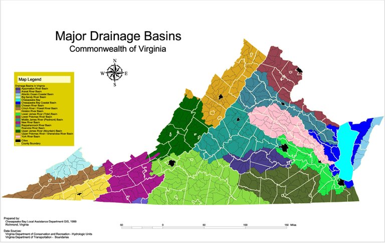
Drainage Basins of Virginia/Source/License: CC BY 2.0/ Author: J. Albert Bowden
Rainwater drainage systems
Rainwater drainage systems fall into the category of hydraulic structures meant for the protection of the environment and natural resources. The assessment of flood hazard in urban basins situated within the area of study is necessary before any sort of preliminary study can take place. Obviously, this depends on the availability of accurate technical data from recent hydraulic studies of the area of interest, and also the options provided by technical software that enable engineers to run runoff simulations.
Building a model
Drainage systems are first modeled and studied taking into consideration the desirable hydraulic performance, which depends on flood events of different durations and recurrence intervals. Those hypothetical flood events are calculated using the intensity-duration-frequency curve (IDF), which is a mathematical formula that relates rainfall intensity (mm/h) with its duration (hrs) and recurrence interval (yrs). Of course, to get your hands on the generalized equation of IDF curves, you need to visit a nearby meteorological station.
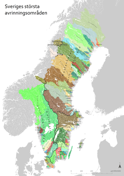
Drainage Basins of Sweden/Source/License: CC BY 2.5/ Author: Moralist
Adding virtual rain gauges
Once you have obtained the IDF curves and all the topographic information required, it's time to move on and start designing the drainage system. Having delineated all urban sub-basins based on the natural hydrographic network, and after all the manholes, conduits and outfalls of the drainage system are inserted in our model together with their hydraulic characteristics, you can now build the necessary design hyetographs, using the equation of IDF curves.
It's a quite simple process once the equation is available, and by using a time step of 10 minutes combined with a series of different rainfall durations and recurrence intervals, we can estimate the rainfall intensity and build the design hyetographs, which will be used to describe our flood events. For the simulation of the system, which is run in order to acquire all the necessary information regarding a number of technical terms, it is important to use the dynamic wave method, as it is the one that provides the best approximation of the system operation, mainly because it is based on the theory of unsteady flow in open channels.
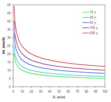
IDF curves of given area of study for different recurrence intervals/Source/License: CC BY 2.0/ Author: Tempscat
Simulation
All this mess in order to compute several hydraulic quantities such as discharge, flow depth, flow velocity and Froude number for every conduit in every flood event. All the aforementioned quantities play a very significant role, as the simulation itself allows engineers to correct the model if necessary, with the aim of creating a final model that is able to convey water safely for flood events with recurrence intervals that exceed even 10,000 years in some cases. In other words, only once every ten thousand years will there be a storm intense enough to surcharge the conduits and flood the manholes. Pretty badass engineering, no?
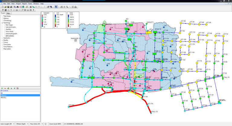
Urban drainage system model in SWMM/Source/License: CC BY-SA 4.0/ Author: Dickinsonre
The final computational steps include the estimation of discharge hydrographs at the outfalls of the sytem, the estimation of a series of hydraulic quantities for every conduit of the network during all rainfall events, and the simulation of hydraulic routing for both minor and major rainfall events. The main output of the final studies ahead of the construction of the system is a series of discharge hydrographs at the outfall of the basin, as is the case for existing drainage systems being studied.
Thanks for reading.
References
Textbooks:
Cassidy, John J., Chaudhry, M. Hanif, and Roberson, John A. "Hydraulic Engineering", John Wiley & Sons, 1998
Prasuhn, Alan L. ''Fundamentals of Hydraulic Engineering", Holt, Rinehart, and Winston: New York, 1987
Τσακίρης Γ, ''Υδραυλικά Έργα - Τόμος I - Αστικά Υδραυλικά Έργα", Αθήνα, 2010
Τσακίρης Γ, "Υδατικοί Πόροι - Τεχνική Υδρολογία & Εισαγωγή στη Διαχείριση Υδατικών Πόρων", Αθήνα, 2013
Links:
https://www.sciencedirect.com/topics/earth-and-planetary-sciences/urban-drainage
https://www.gov.uk/government/publications/best-management-practices-for-urban-drainage
https://www.epa.gov/water-research/storm-water-management-model-swmm

I have to admit (as usual) that some of this was complicated for me, but I kept thinking of two areas as I read: Las Vegas and Long Island.
Throughout Las Vegas there are 'washes', large pit-type areas meant to catch overflow from the desert during a deluge. These sometimes are death traps for the homeless who sleep there during dry spells and then are swept away during a sudden deluge--deluges happen all the time during 'monsoon' season in Las Vegas. Also, the system of washes is obviously imperfect because I can also recall water rushing down Las Vegas Boulevard and carrying away statues in front of Caesar's Palace.
Second place I think of is Long Island. Climate change has wreaked havoc on traditional flood patterns and new maps are released periodically that anticipate flood zones, as you indicate on your occurrence interval map. It's stunning to watch the maps predict potential events over different spans. The maps are dynamic so they are quite realistic.
Anyway, I enjoyed your map of Sweden. But then, I like maps :)
Hey there, thanks for reading!
The saddest part is that there are still homeless people in the world, this is what we should look to work on. On another note, it might not be just about the structural efficiency of the washes; deforestation plays a huge part as well.
Again, deforestation and lack of urban planning are key factors in this. Many countries have yet to develop advanced systems containing information regarding ownership, possession or other rights in land, which can be recorded to provide evidence of title and/or to prevent unlawful disposal.
Thank you for your response.
Yes, planning. Las Vegas exists in defiance of its environment (water-parched desert). And, the passion for living on a patch of sand--which is in evidence all along the East Coast of the U.S.--may be misguided also.
As for the homeless: so many in Las Vegas. I haven't been there for years. My husband and I speculated then that the great number might have been due to a combination of balmy climate and ready access to gambling. Although, obviously homeless is not unique to Las Vegas.
Regards,
AG
This post has been voted on by the SteemSTEM curation team and voting trail. It is elligible for support from @curie and @minnowbooster.
If you appreciate the work we are doing, then consider supporting our witness @stem.witness. Additional witness support to the curie witness would be appreciated as well.
For additional information please join us on the SteemSTEM discord and to get to know the rest of the community!
Please consider using the steemstem.io app and/or including @steemstem in the list of beneficiaries of this post. This could yield a stronger support from SteemSTEM.