How earthquakes are caused by Tsunami?
Ever since our earth came into being, a series of changes have been taking place on it in an orderly manner, as a result of which many dry parts of the earth are submerged in the sea and many new islands emerge at sea level. It also happens that for thousands of miles a large part of the land is lost to the sea or new shores emerge from the retreat of the sea.
According to geologists, these changes in the earth are caused by the mild waves of earthquakes caused by the vibrations of the earth's inner rocks. According to experts, about 12,000 earthquakes occur on our planet every year. Most of them we don't even know about. Of these, only about a thousand earthquakes can be felt by humans without scientific instruments. More or less hundreds of earthquakes are catastrophic. However, an earthquake occurs in a year which can rightly be called doomsday.
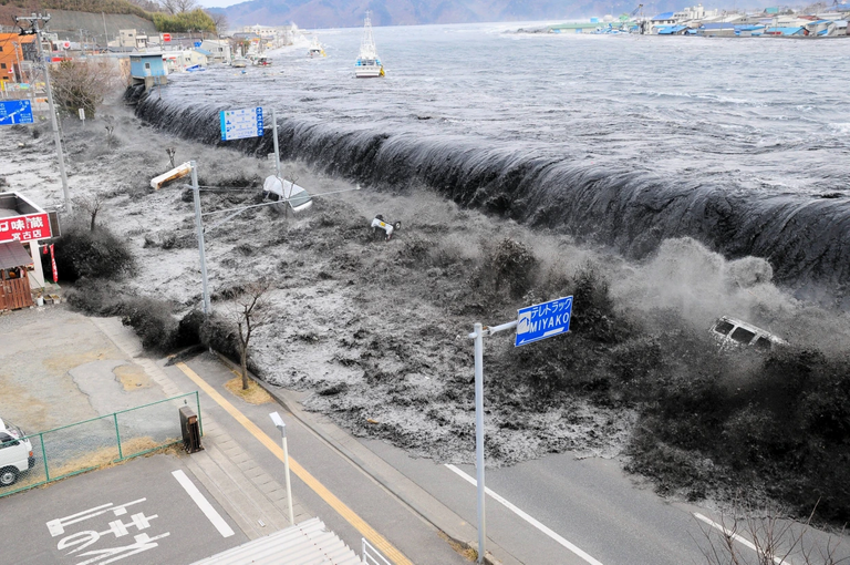
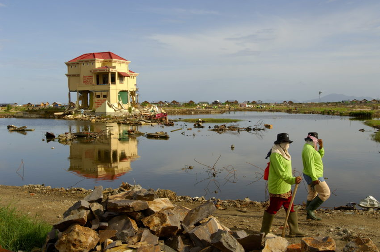
Earthquakes cause thousands of houses and high-rise buildings to collapse, but underwater earthquakes are far more dangerous. As a result of such earthquakes the waves of the sea become uncontrollable and several hundred feet high waves rush towards the shore like a monster and drown the whole city at the sight of it. The people of the Atlantic Ocean, Pacific Islands and the Japanese Islands have been frequently exposed to such underwater earthquakes. The Japanese called these mountain-like waves tsunamis. The Japanese word tsunami is a combination of two words. 'Tsu' means beach and harbor and 'Nami' refers to high and long waves.
What is a tsunami? And why is it born? In order to know it, we discuss the structure of the earth. Geologists say that our earth is made up of layers of rocks. The upper surface of the earth is called crust. Its depth is 35 to 70 kms and in the sea it is 5 to 10 kms. The second layer beneath it is called the mantle. The mantle is 2,900 km deep and consists of two parts. The upper part is called static lithosphere and the lower part is called liquid asthenosphere. Then the last layer of the earth is the center of the earth which is 3,500 kilometers deep and consists of molten lava magma.
The upper crust of the earth, which is made up of different rocks, is neither static nor always in one form, but gradually changes. Although the surface of the earth seems to be uniform and smooth to us, but in depth it is divided into 15 different kinds of pieces which are called the plates of the earth. These plates are not separated from each other, nor are they perfectly joined together, but they float constantly on the lava magma below, as if large pieces of wood were floating on the still surface of a lake. Under normal conditions, the movement of these plates is very slight and they cover a distance of about 6 inches in a year.
When the magma in the earth's crust is stirred, these plates also begin to move with this shock. Magma provides energy for the movement of these plates. Mountains on Earth balance the movement of magma and block its pressure. Constant swimming and movement cause geological changes in the earth.
If at any time the magma flood suddenly increases, the connected plates collide with each other. This collision produces abnormal energy or pressure underground that becomes unbearable for the surrounding rocks, and this energy is used in the form of massive explosions and terrifying thunderstorms in the form of earthquakes in plateau cracks and at sea level appear in the form of a tsunami. This causes severe flooding in the water and the sea sometimes gets out of control and makes waves several hundred feet high which can destroy any coastal city in a single moment.
The pressure of magma also changes the surface of the earth's plates, causing sudden geological changes and creating tidal waves in the earth. Some parts of the land emerge and become new islands and some islands sink into the sea.
How did the tsunami hit South Asia on December 26, 2004? The epicenter was reported 155 miles southeast of Banda Aceh, the capital of Aceh province in the Indonesian state of Sumatra, according to the US Geological Survey. The two plates of the planet located in the Indian Ocean, the Burma Plate and the Indian Plate, move about 6 cm per year. Due to the unusual flooding of underground lava magma, these plates suddenly moved 15 meters. The collision released a tremendous amount of energy that reached the surface of the earth in the form of circles within 200 seconds and took the form of an earthquake. The quake measured 9.1 on the Richter scale.
The tsunami reached the coast of Banda Aceh at a speed of 600 miles per hour, almost completely destroying the city. The tsunami hit Malaysia, Thailand, Burma and Bangladesh in a circle and reached Sri Lanka and India in 1 to 2 hours, reaching the Maldives in 4 hours and Somalia, Seychelles, Kenya and Tanzania in 7 to 8 hours, killing dozens.
Thank you for reading! Stay Safe!👋😌