Use of GPS receivers as a technological support tool in the agricultural sector
(Edited)
Dear readers, in different publications we have been socializing the effectiveness of some technological tools in the agricultural sector, this time we will address the functionality that GPS receivers can have in some agricultural activities, let's start by pointing out that the GPS "Global Positioning System" is possible because of the number of satellites that have been launched into space by countries like the United States, Those satellites had a military vision, but seeing that satellite signals can be received by anyone, the development of portable devices was initiated to receive those signals, which allows to have an exact position on any surface.
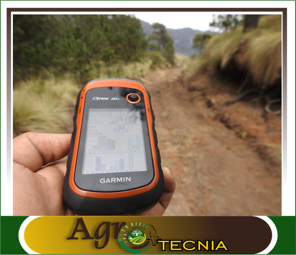
Design made by @amestyj 2020, with image of public domain 1
Generally the portable devices have a built-in antenna and have several channels, for a better obtaining of the satellite signals, within the functions that can present are those of measuring the barometric pressure, changes of altitude and with the electronic compass that comes incorporated in the equipment can be obtained data like the direction of the movement, the hour, the speed, the distance to the destiny among other functions like the saving of a great amount of points and routes, ideal to make some topographical measurements with exactitude.
Based on these premises, one of the main functions that they have had in the agricultural production units is the obtaining of points or routes that allow to delimit the used surfaces, which has left in the past on the part of the producers the topographic measurements with another type of tools, the use of GPS can make agile in time the taking of points for the establishment of electrical or conventional fences, This technology has been used by some National Land Institutes, which have a digitalized database, generating wide sectorial maps delimiting all the production units.
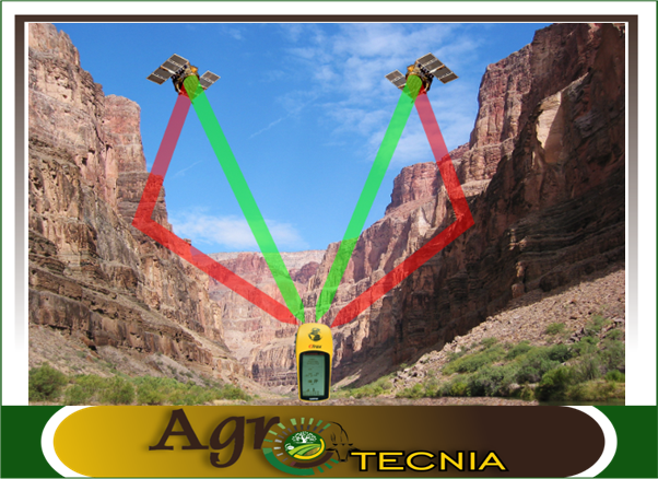
Design made by @amestyj 2020, with image of public domain Javiersanp 2010
On the other hand, it has also been used for the location of agricultural machinery that allows to supervise if they are carrying out the agronomic tasks that have been planned, in the same way in the veterinary epidemiology it has been used, since when they occur or outbreak of some disease of economic importance or that they have influence in the public health, it becomes necessary to obtain the exact location of the sectors in which they are focuses, that added to it is used a software with a system of Geographical Information that allows to store data of interest.
In 2007, my country carried out an agricultural census using a portable device to obtain the global positioning of the farms, The whole process consisted of collecting the information, storing the information, consulting the information, analyzing the information to obtain updated data that would allow us to know the deficiencies and strengths of the agricultural sectors surveyed, creating sectorized maps thanks to the points obtained with the portable global positioning device.
Dear readers, these are some of the different uses that GPS can have in agricultural production systems. Technology has been gaining ground for many years in different economic areas, and as I have mentioned in my publications on this subject, producers must be trained in the use of these devices and must be able to acquire these tools through financing.

From agrotecnia we reiterate our gratitude to our followers and all communities that value our agricultural content, this commits us to continue sharing quality information with the entire beehive.


0
0
0.000
This post has been manually curated by @bala41288 from Indiaunited community. Join us on our Discord Server.
Do you know that you can earn a passive income by delegating to @indiaunited. We share 80 % of the curation rewards with the delegators.
Here are some handy links for delegations: 100HP, 250HP, 500HP, 1000HP.
Read our latest announcement post to get more information.
Please contribute to the community by upvoting this comment and posts made by @indiaunited.
Greetings friends of @indiaunited thanks for the support you give to my content, I wish you continue to reap success !
Hello dear friend @amestyj good day
As always excellent information, technology is undoubtedly very good help in the field. I really appreciate the great work behind each information you provide us. Thanks a lot
I take this opportunity to wish you a splendid day,
A hug for you and a big love for your whole family
Greetings dear @jlufer I hope you are well, thank you for your comment and assessment of my content, no doubt this type of technology is of great help to the producer, but as I mentioned, access to it should be facilitated through funding.
See you later brother, blessings for you and your family.
the technology is awesome, and GPS is practically something indispensable today.It is very important to convey this knowledge to all people Well this is not to lead to evolve faster.
Thank you for always contributing such good information.
Hi friend, I agree with you, the GPS is a very useful tool used in different professional areas, therefore, it is important to know the basic handling of them as you mention, see you later and thanks for your valuable comment !
This type of technology is very important for the agricultural and economic development of countries that are at the forefront of agrifood activity. Greetings and thanks for sharing
Greetings friend @carlos84, no doubt they are very useful tools, which should be easily accessible for agricultural activities !