FACILITY MAPPING USING ARCGIS
Hi Hivians, it is a beautiful Friday! Today I want to go deeper into sharing the procedures for producing a facility map with ArcGIS.
Using one of the states in Nigeria as a case study, Kano state.
The aim of the project was to acquire data on location to show the accessibility and distribution of WASH (Water Sanitation and Health) facilities in the local government areas in Kano State.
Here are the specific objectives of the project:
a.To produce a map showing the water facility distributions in the local government areas.
b.To produce a map showing the distribution of infrastructure in the Local Government Areas (LGAs) in Kano state.
Scope of the Project
The scope of work was as follows:
a.Data acquisition
b.Data processing
c.Map production
Detailed Explanation of Map Production
Data Acquisition
To fulfill the aim and objectives of this project, the planning and methodology for data acquisition were carried out by the company. The data used for the production of maps was acquired on location using handheld GPS. Every necessary piece of information gotten from fieldwork was captured and stored in a server and was uploaded to MS-Excel.
For data validation, the field data gotten was in Eastings and Northings, and was uploaded and converted to a .kml file in ArcGIS and then uploaded to Google Earth for validation.
After data validation, the data was checked and cleaned of possible errors. Data quality control was also carried out to determine if the data meets overall quality goals, coordinate data was mapped to validate location information
Data Processing
Due to how voluminous the data was, there was a need to have a robust data structure, therefore, the shapefiles created on ArcMap were clipped, copied, saved, and stored in a geodatabase called ModelGDB.
The Geodatabase was categorized into two datasets, the Fundamental dataset, and the Thematic dataset. The fundamental dataset is the necessary features required for the production of each map which includes roads, rivers, railways, boundary polygons, and waterbodies while the thematic dataset is the features like infrastructures, communities, and water facilities.
Map Production Methodology
1.To begin, we load the data on MS-Excel and extract the thematic data (community) from the entire data given. The extracted information include; community names and ward names, latitude, and longitude.
2.The Excel data is then linked to ArcGIS to be exported as an event, this is because the event will enable the coordinates to be viewed and plotted on the ArcMAP. The event is then copied and first saved as a shapefile to be sure that the data is clean.
3.I created the geodatabase and imported the shapefiles into it. I dragged it into the GIS interface and that created an additional layer.
4.After the first three steps are carried out, click new to select a new template depending on the size of the LGA boundary polygon (landscape or portrait).
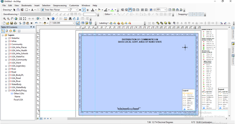
Image showing an ArcMap template for the map production
5.Click on the LGA community to be able to add the map to the GIS interface.
6.On the dialog box displayed for ‘set data source’ select the LGA to work on from the ModelGDB.
7.Go to LGA bundryply, select by attribute (query for LGA of interest e.g Minjibir LGA), then change focal LGA from 0 to 1
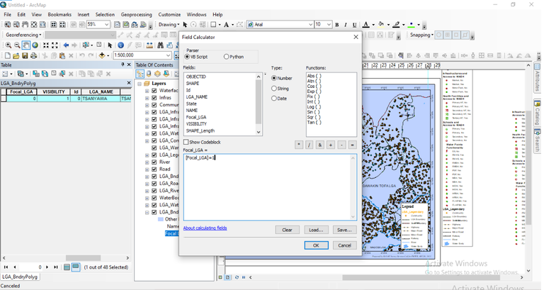
Showing focal LGAs
8.Go to the GIS interface, zoom to best fit the template, and save the scale in the ArcMap bookmark.
![],.( )
)
ArcMap showing how bookmark is saved
9.Click on the community layer, select by attribute to select the communities in Minjibir, then copy and paste in LGA_Community.
10.Next, click on road layer, then select by attribute, paste the query road exemption and apply.
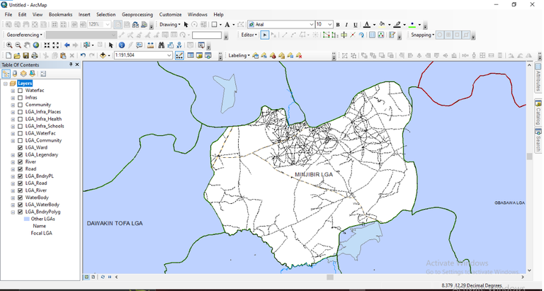
Image showing the road network
11.Click on the Waterfac layer to edit features and select by attribute, right-click on the interface to copy and paste in LGA_Waterfac. The same procedure is done for LGA_infra places.
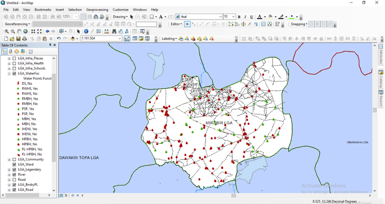
Showing LGA_Waterfac - LGA water facilities
FINAL RESULTS
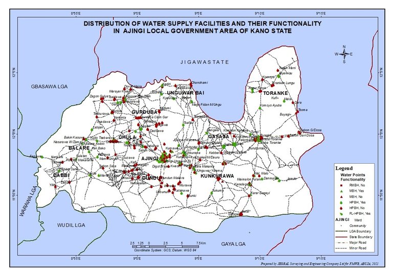
Showing Water facility Map of Ajingi LGA
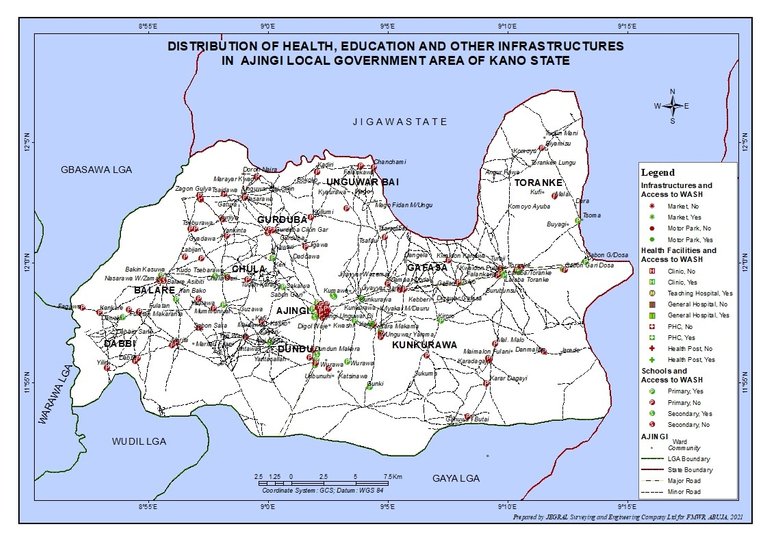
Showing infrastructures map Ajingi LGA
Thanks for your contribution to the STEMsocial community. Feel free to join us on discord to get to know the rest of us!
Please consider delegating to the @stemsocial account (85% of the curation rewards are returned).
You may also include @stemsocial as a beneficiary of the rewards of this post to get a stronger support.
Woah, this is new to me but the project is a good one.
Thanks for sharing.
You're welcome 🤗
I'm glad it was an added knowledge to you 🙂