Ice and Tide
In the previous section of Earth in Upheaval Immanuel Velikovsky put forward a catastrophist hypothesis to explain the recent ice ages through which our planet has passed. In Ice and Tide, the fifth section of Chapter IX, he attempts to bolster this hypothesis by demonstrating that many of the geomorphological effects that are usually attributed to ice were actually caused by water:
Having shown that only global catastrophes could have brought about the building and spreading of ice covers, I shall now go on to demonstrate that many effects attributed to ice were caused not by it but by onrushing water. The simplicity with which cosmic catastrophes can explain the origin of the continental ice covers should not make us uncritical. The same catastrophes caused great tides to rush over continents. Both phenomena―waves of translation and ice covers―took place. ―Velikovsky 127
If it is conceded that the Earth experienced a pole-shift, then it can hardly be denied that it also experienced megatsunamis―Velikovsky uses the less precise term tidal waves. He believed that the rate at which the Earth rotates upon its axis was altered:
Tidal waves traversed continents, moving by inertia when the daily rotation of the earth was disturbed; the ocean water also retreated from the equatorial to the polar regions, returning to the equator with the adjustment of the diurnal rotation. ―Velikovsky 127
But even if this did not happen during the pole-shift, devastating megatsunamis would still have been generated if the crust slid over the mantle. The only way of avoiding megatsunamis is by rejecting outright the idea of a pole-shift.
Among the phenomena which Velikovsky attributes to these megatsunamis are the following:
The dispersal of erratic boulders.
The deposition of marine sediments inland.
The deposition of glacial drift across continents.
The erosion of topsoil.
The excavation of lakes and valleys.
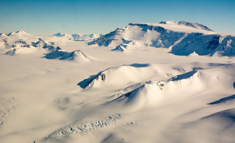
Is Ice Destructive or Protective?
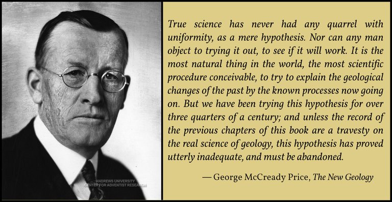
Velikovsky next cites one of his favourite sources, the Canadian creationist George McCready Price, to the effect that ice sheets, contrary to the mainstream view, protect the underlying landscape from erosion:
The opponents of the Ice Age theory, the last of which is George McCready Price, pointed to the effect of the ice cover in Antarctica on the rocks beneath: ice plays there a protective and not an eroding role; it shields the underlying rock from the erosive action of the elements and especially of the high velocity winds that blow most of the year in this part of the world. Yet in rapid motion, with many stone fragments and other debris under it, ice could scratch the bedrock and erode and flute the slopes of valleys. But it is doubtful that the weight of the ice would excavate lake basins in cold, hard rock.―Velikovsky 127–128
No reference is provided for this opinion, but McCready Price expresses it in The Modern Flood Theory of Geology, which was published in 1935:
Recent investigations in the South Polar region have led to the conclusion that the huge ice-caps “protect the underlying land,” instead of digging out valleys and lakes, as we have so long been taught. These recent investigators also tell us that the ice-sheets of the Antarctic exercise “a predominantly conservative influence”; while in their opinion “ice plus water” must have been the effective agents in producing the so-called “glacial” phenomena of the long ago. And they are convinced of the “importance of sea ice as a geological agent,” indicating that the earlier students of this subject were very likely right in their theory of Drift ice when driven by violent storms as quite competent to do all the work which has for so long been attributed to land ice and huge continental ice caps. ― McCready Price 62–63
McCready Price does not identify the source of his quotations. Who were these recent investigators of the South Polar region? In the late 1920s and early 1930s Admiral Richard E Byrd led two expeditions to Antarctica:
First Antarctic Expedition (1928–1930)
Second Antarctic Expedition (1933–1934)
Byrd’s geologist and chief scientist during his first expeditions was Laurence McKinley Gould, an assistant professor at the University of Michigan. In 1931 Gould published an account of his experiences on the expedition, Cold: The Record of an Antarctic Sledge Journey, but there is nothing in this work about the protective nature of ice caps.
The leading geologist during Byrd’s second expedition was Franklin Alton Wade, who was then studying for his doctorate at the Johns Hopkins University in Baltimore, Maryland. In 1939 the physicist Thomas Poulter, who had been chief scientist and second in command during the expedition, published a paper summarizing the scientific work carried out by him and his colleagues. Like Gould’s account of the first expedition, there is nothing here to support McCready Price’s quotations.

There were other expeditions to Antarctica in the 1920s:
The British Imperial Antarctic Expedition (1920–1922)
The Shackleton-Rowett Expedition (1921–1922)
The Discovery Investigations (1924–1951)
The British Australian and New Zealand Antarctic Research Expedition (1929–1931)
I have not been able to find any reference to the conservative nature of ice sheets in the scientific reports of any of these expeditions. Nevertheless, there is nothing controversial about this claim. Today it is widely conceded that ice sheets may protect the underlying land rather than eroding it:
Cold-based glaciers have long been recognized as capable of covering and protecting landscapes. However, recent studies of modern cold-based glaciers in Antarctica show that, in some situations, erosion, deformation and deposition can occur. Recognizing the dual ability of cold-based glaciers to protect and preserve surfaces on the one hand and erode and modify on the other is important for correctly interpreting the often-subtle imprint of cold-based glaciers on landscapes. ―Atkins 299
The argument is that cold-based glaciers and ice sheets are frozen to the substrate. As they cannot slide over the land, they are unable to erode it.

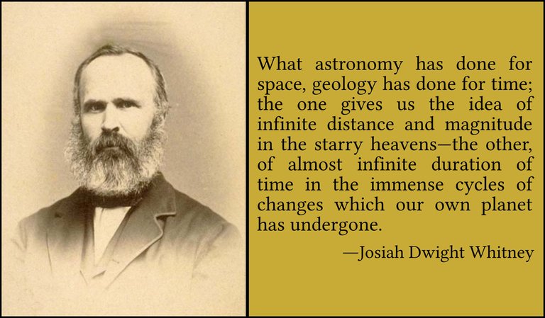
Two Divergent Opinions
Velikovsky next compares two divergent opinions on the roles of water and ice in shaping the landscape. The first of these was expressed in 1874 by the Scottish geologist James Geikie, younger brother of Archibald. James was cited by Velikovsky in Chapter II and Archibald in Chapter IV:
To describe the different theories which have appeared and disappeared, ever since the superficial deposits began to attract the attention of geologists, would be a thankless and perhaps a useless task. One of these theories conceived that somehow and somewhere in the far north a series of gigantic waves was mysteriously propagated. These waves were supposed to have precipitated themselves upon the land, and then swept madly on over mountain and valley alike, carrying along with them a mighty burden of rocks and stones and rubbish. Such deluges were styled “waves of translation,” and the till was believed to represent the materials which they hurried along with them in their wild course across the country. The stones and boulders as they rattled down one mountain’s side and up another, were smoothed and scratched, and the solid rocks over which they careered received a similar kind of treatment. After the water disappeared the stones were found confusedly huddled together in a paste of clay, but occasional big blocks, often far-travelled, might be seen perched in lonely positions on hilltops, or scattered over hill-slopes like flocks of sheep; while mounds of sand and gravel rolled themselves out hero and there in the Lowlands. Such in a few words was the theory of great debacles or waves of translation. It was unfortunate for this theory that it violated at the very outset the first principles of the science, by assuming the former existence of a cause which there was little in nature to warrant. Large waves it was known had certainly been raised by sudden movements of the earth’s crust, and had several times caused great damage to seaport towns; but gigantic rushes of water across a whole country had fortunately never been experienced within the memory of man. The theory, indeed, had only been advanced in a kind of desperation, for geologists were quite at their wits’ end to discover any natural cause that would account for the peculiar phenomena of the drift―they could see neither rocks being rounded and scratched nor till being formed anywhere―the causes to which these were due had apparently ceased to operate―and so the perplexed philosophers were in a manner compelled to fall back upon waves of translation. They did not, however, attempt to uphold this theory very strenuously. It was felt that, even granting the probability of great waves of translation having swept across the land, still a number of facts remained which could neither be accounted for nor yet explained away. ―Geikie 26–27

An opposing view was presented by the amateur catastrophist Henry Hoyle Howorth, who was first cited by Velikovsky in the opening chapter of Earth in Upheaval. In The Glacial Nightmare and the Flood (1893), Howorth argued that Geikie’s waves of translation could have been generated by natural movements of the Earth’s crust:
Presently came a tremendous catastrophe, the cause of which, as I have tried to show in the Geological Magazine, was the rapid and perhaps sudden upheaval of some of the largest mountain chains in the world, accompanied probably by great subsidences of land elsewhere. The breaking up of the earth’s crust at this time, of which the evidence seems to be overwhelming, necessarily caused great waves of translation to traverse wide continental areas, as Scott Russell, Hopkins, Whewell, and Murchison argued they would, and these waves of translation as necessarily drowned the great beasts and their companions, including palaeolithic man, and covered them with continuous mantles of loam, clay, gravel and sand, as we find them drowned and covered. They also necessarily took up the great blocks which the glaciers had fashioned, and transported them to a certain distance and distributed them, and the Drift associated with them, as we find them distributed. This Induction, whose details are contained in the following pages, seems to me to be complete, not only because it adequately explains the facts, but because it is the only theory that does so, and I know nothing against it, but the almost pathetic devotion of a large school of thinkers to the Religion founded by Hutton, whose High Priest was Lyell, and which in essence is based on a priori arguments like those which dominated mediaeval scholasticism and made it so barren. ―Howorth xx–xxi
Velikovsky, however, believes that his theory of a pole-shift explains the facts even better than Howorth’s mountain-building events:
As we have learned on preceding pages, a disturbance in the axial rotation of the earth must have created a displacement of the oceans and their irruption on land; and this very cause―the disturbance in the axial rotation of the earth―must have acted also in order to build the continental ice covers; it also changed the profile of the earth’s crust, lifting some mountains and leveling others.
All this created scenes of the utmost complexity. ―Velikovsky 128
The Northern Drift of Northeastern America
For an example of this complexity Velikovsky turns to the American geologist Josiah Dwight Whitney of Harvard University and the California Geological Survey. In The Climatic Changes of Later Geological Times (1882) Whitney is forced to concede the shortcomings of the glacial theory:
We next pass to a region where the Glacial phenomena exhibit the highest degree of complexity. We are beset with difficulties when we attempt to solve the problem presented by the Northern Drift in Northeastern America. It is indeed remarkable what dissimilar conditions are presented on the two opposite sides of this continent; but the complications of our Drift region have already been the subject of sufficient comment, and we need not enlarge farther upon them. Absence of a definitely known centre of glaciation; extreme complexity in the direction of the striation; proofs of the former presence of the sea over a part of the region, and of fresh water over another extensive portion; enormous accumulations of detrital material evidently deposited by water; occasional peculiar transportation of boulders in a manner not in harmony with anything we see ice doing at the present time; occurrence of linear accumulations of sand, gravel, and boulders closely resembling the åsar [ie eskers] in character; proofs in some parts of the Drift region of the prevalence during the Glacial epoch of a colder climate, and in others of one warmer than that now existing―these are some of the difficulties which must be met by those who undertake to solve the problem of the Northern Drift of Northeastern America. That the assumption of a lower mean temperature of the earth would be of no assistance to the investigator in surmounting these difficulties seems to the writer to have been clearly established in the course of the present chapter. ―Whitney 391–392
Corroborative testimony is provided by Richard Foster Flint, Professor of Geology at Yale University, whose Glacial Geology and the Pleistocene Epoch has been quoted more than half-a-dozen times already in Earth in Upheaval:
Interglacial Deposits of Uncertain Stratigraphic Position
A number of interglacial strata have not been fitted into the composite standard section. One of these occurs at Kirmington on the Lincolnshire coast. It underlies till that is believed to correlate with the Hessle drift of Yorkshire and overlies a till of undetermined date. It consists of estuarine silt with a subarctic mollusk fauna. Whether it belongs to a part of the Hoxne succession or to a younger horizon, it does not in any event record full interglacial conditions.
A more illuminating exposure occurs in the cliffs at Holderness, Yorkshire. It consists of stratified sediments, largely marine and largely gravel, with mollusks (mostly like those living in British waters today), seal, and walrus. In addition there is present Corbicula fluminalis, a fresh-water mollusk of temperate-climate habitat. Despite its anomalous elements, this deposit is classed as interglacial. It lies between tills believed to be equivalents of the Lower and Upper Chalky drifts respectively; if this is so, it too would seem to belong to the same interglacial as the Hoxne deposits. ―Flint 341–342
Velikovsky concludes this paragraph with the following observation:
In similar strata in Yorkshire hippopotami are found, too. ―Velikovsky 129
No source is cited for this nugget of information. I presume Velikovsky is remembering something he wrote in Chapter II in The Caves of England, the section in which James Geikie was first cited:
In 1823, William Buckland, professor of geology at the University of Oxford, published his Reliquiae diluvianae (Relics of the Flood), with the subtitle, Observations on the organic remains contained in caves, fissures, and diluvial gravel, and on other geological phenomena, attesting the action of an universal deluge. Buckland was one of the great authorities on geology of the first half of the nineteenth century. In a cave in Kirkdale in Yorkshire, eighty feet [24 m] above the valley, under a floor covering of stalagmites, he found teeth and bones of elephants, rhinoceroses, hippopotami, horses, deer, tigers (the teeth of which were “larger than those of the largest lion or Bengal tiger”), bears, wolves, hyenas, foxes, hares, rabbits, as well as bones of ravens, pigeons, larks, snipe, and ducks. Many of the animals had died “before the first set, or milk teeth, had been shed.” ―Velikovsky 14
Erratic Boulders Again
Not for the first time Velikovsky turns to the erratic boulders in support of his catastrophist thesis. These were originally thought to have been scattered across the surface of the Earth by the Noachic Deluge, but with the evolution of the Glacial Theory their distribution was subsequently attributed to ice. Velikovsky, however, is having none of it:
The glaciers in the Alps served as observational material for deductions concerning the continental ice cover. However, alpine glaciers carry stones downhill, not uphill, and the general question was asked whether ice could carry rocks uphill. ―Velikovsky 129
If Velikovsky is to be believed, this question was asked by George Frederick Wright, Professor of Geology at Oberlin Theological Seminary in Ohio. The citation is to page 634 of the fifth edition of The Ice Age in North America, but I cannot find anything on this page to corroborate Velikovsky’s statement. Wright does not even mention the Alps. It appears that the correct citation is to page 249, where the author writes:
Bowlders [sic] of Alpine glaciers seem always to descend to their final resting-place, but we have innumerable proofs that the American ice-sheet managed, in some way, to carry bowlders from valleys up to mountain-tops, although the amount of elevation in many cases, if not in all cases, may be much less than we are inclined, on a first inspection of the facts, to take for granted. ―Wright 249
Wright attempts to make light of this anomaly, arguing that the differences in elevation are always quite modest, but he finally concedes the point:
Still, it remains a problem by what sort of internal movement a stone held in the ice can ascend, however gentle may be the gradient upward. That internal movements take place in all glaciers, is made visible to the spectator by their spoonshaped stratification, and by the different rates at which their upper, lower, middle, and lateral parts move along, as well as by the fact that they press forward over rock-barriers. But so general a statement has no scientific value when evoked to explain the actual translation of a bowlder up a mountainslope. In fact, our knowledge of how such an operation was performed is as vague as possible, and demands the attention of hydraulic engineers. ―Wright 249–250
Erratics have not only been found at elevations that defy explanation: they have also been found in places far beyond the extent of the Pleistocene ice sheets:
Erratic boulders are often found in places where continental ice could hardly have deposited them. Charles Darwin inquired and learned that erratics are found on the Azores, islands separated from the ice cover by a wide expanse of ocean. ―Velikovsky 129
Once again, no source is cited for this piece of information, but it is not hard to find. In the first edition of his most famous work, On the Origin of Species, Darwin writes:
As icebergs are known to be sometimes loaded with earth and stones, and have even carried brushwood, bones, and the nest of a land-bird, I can hardly doubt that they must occasionally have transported seeds from one part to another of the arctic and antarctic regions, as suggested by Lyell; and during the Glacial period from one part of the now temperate regions to another. In the Azores, from the large number of the species of plants common to Europe, in comparison with the plants of other oceanic islands nearer to the mainland, and (as remarked by Mr. H. C. Watson) from the somewhat northern character of the flora in comparison with the latitude, I suspected that these islands had been partly stocked by ice-borne seeds, during the Glacial epoch. At my request Sir C. Lyell wrote to M. Hartung to inquire whether he had observed erratic boulders on these islands, and he answered that he had found large fragments of granite and other rocks, which do not occur in the archipelago. Hence we may safely infer that icebergs formerly landed their rocky burthens on the shores of these mid-ocean islands, and it is at least possible that they may have brought thither the seeds of northern plants. ―Darwin 1859:363
Far from being dismayed by the discovery of erratics in the Azores, Darwin regarded it as striking confirmation of a theory proposed by Charles Lyell, according to which erratics were transported not by glaciers but by icebergs. But during glacial periods of the Pleistocene Ice Age the sea level was about 120 m lower than it is today. Even if icebergs transported erratics as far south as the Azores, they would have dropped them offshore in the ocean. Darwin does not explain how these erratics could possibly have ended up inland, where Hartung observed them.
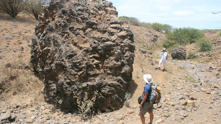
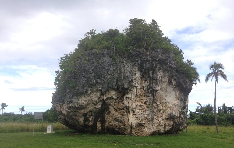
Moreover, in an earlier article―Icebergs―we learned that some massive erratics have been found on remote islands of the Pacific Ocean, far from the poles. These megaclasts cannot possibly have been rafted there by icebergs.
Velikovsky is perhaps on shakier ground when he cites the English geologist Joseph George Cumming:
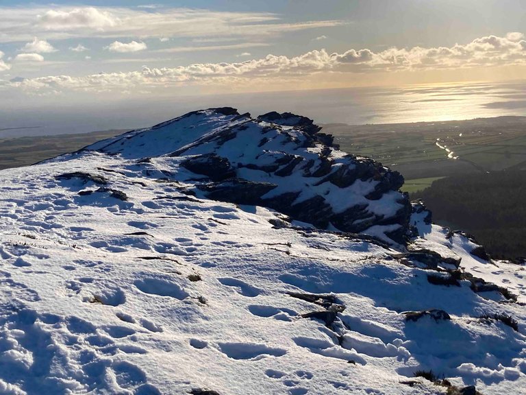
Cumming described erratics close to the summit of the Isle of Man amidst the Irish Sea, where only waves could have lifted them. ―Velikovsky 130
The erratics referred to by Cumming were discovered close to the summit of the South Barrule. Although this is the highest hill in the south of the island, it is only 483 m high. The highest point in the Isle of Man, Snaefell, stands 621 m above sea level. Furthermore, it is now accepted that during the Pleistocene Ice Age, a huge glacier flowed down the Irish Sea―the Irish Sea Glacier. This glacier probably overran the whole of the island, depositing erratics at high altitudes as it went:
Ice-sheet development during the late Devensian was complex and has been modelled only in general terms ... Boulton et al. (1977) estimated that at the LGM the relative elevation of the ice-sheet surface over the Southern Uplands and over the Lake District may have been in excess of 1900 m and about 1700 m respectively. However, in the Lake District, palaeonunataks have since been identified, indicating that the ice-sheet was thinner and that its surface stood at between 800–870 m above OD ... Nevertheless, even the most conservative of estimates suggest that there was about 700 m of ice over the Irish Sea basin during the LGM, when Snaefell (621 m) on the Isle of Man was buried. ―McMillan et al 7
Velikovsky also throws into the mix evidence of erratics in other parts of the globe:
In Labrador boulders have been seen, rammed against the slopes of the hills, which could have been done only by a tidal wave. As already said, in India, in an earlier ice age, detritus and blocks were carried, not from the land toward the sea, but in the opposite direction, from the sea up the Himalayas, and not from higher latitudes toward lower, but in the opposite direction. The whales in the hills of Vermont and Quebec were cast there by an irrupting ocean. ―Velikovsky 130
The facts about India and Vermont & Quebec were given in two earlier sections of Earth in Upheaval:
Chapter VI: The Himalayas
Chapter IV: Whales in the Mountains
No source is cited for the claim that erratic boulders have been discovered in Labrador that could only have been deposited by tsunamis. I believe, however, that Darwin is the source―though, once again, he is unembarrassed by the presence of erratics at high elevations. In his 1848 paper On the Transportal of Erratic Boulders from a Lower to a Higher Level, we read:
To take the case of North America: Mr. Lyell has shown, from an independent train of reasoning, that this country during the glacial period slowly subsided to a considerable amount: several American geologists have come to a similar conclusion, and they believe that the subsidence amounted to two or three thousand feet [600–900 m], or even more. Let us suppose a sinking movement to be now going on in the estuary of the St. Lawrence or on the coast of Labrador, where we know, from the observations of Lieut. Brown and Capt. Bayfield, as given by Mr. Lyell (and illustrated by striking sketches), that annually an enormous number of boulders, both on and near the coast, are frozen into the coast-ice and transported to shorter or greater distances; can we doubt, that if during the year the land sunk a few inches or feet, the boulders, whilst actually frozen in or when refrozen during the ensuing winter, would be lifted up and landed so many inches or feet higher up on the coast? Capt. Bayfield, as stated by Mr. Lyell, saw masses of rock, “carried by ice through the straits of Belle Isle, between Newfoundland and the continent, which he conceives may have travelled in the course of years from Baffin’s Bay.” Now if during this probably long course of years,―for the boulders seem generally to be transported only a short distance each winter,―the land had subsided one or two hundred feet [30–60 m], is it not almost certain that they would have been landed so many feet higher up with respect to their former level, in the same manner as would have happened with so much drift timber? It is indeed paradoxical thus to speak of the boulders having been carried up, whilst the land has gone down; for, in fact, the boulders are merely kept by the floating ice at the same level, whilst the land sinks. ―Darwin 1848:319
At several points in this paper Darwin cites Cumming, including the latter’s observation of erratics on the Isle of Man’s South Barrule, so this must have been where Velikovsky first heard of Cumming.
Velikovsky concludes this section with another of those fine pieces of rhetoric for which he was renowned:
The very profusion of erratic boulders in many places of the world, sometimes covering wide stretches of a country, whether carried by ice or by tides, presents the problem of their origin: they must have been broken off the mountains in great numbers at a time when ice and water were thrown into action. The mountains must have been under stress, the massifs must have been heated and split, or shattered by earthquakes; they must have been mashed and twisted and rent when the seas trespassed their borders and carried their billows to mountainous ridges, red and bursting. ―Velikovsky 130
And that’s a good place to stop.
References
- C B Atkins, Geomorphological Evidence of Cold-Based Glacier Activity in South Victoria Land, Antarctica, M J Hambrey (editor) et al, Antarctic Palaeoenvironments and Earth-Surface Processes, Pages 299–318, The Geological Society, London (2013)
- Joseph George Cumming, The Isle of Man: Its History, Physical, Ecclesiastical, Civil, and Legendary, John Van Voorst, London (1848)
- Charles Darwin, On the Transportal of Erratic Boulders from a Lower to a Higher Level, Quarterly Journal of the Geological Society of London, Volume 4, Part 1, Pages 315–323, Longman, Brown, Green, and Longmans, London (1848)
- Charles Darwin, On the Origin of Species by Means of Natural Selection, John Murray, London (1859)
- Richard Foster Flint, Glacial Geology and the Pleistocene Epoch, John Wiley & Sons, Inc, New York (1947)
- James Geikie, The Great Ice Age and Its Relation to the Antiquity of Man, D Appleton and Company, New York (1874)
- Henry Hoyle Howorth, The Glacial Nightmare and the Flood, Volume 1, Sampson Low, Marston & Company, London (1893)
- Thomas C Poulter, The Scientific Work of the Second Byrd Antarctic Expedition, The Scientific Monthly, Volume 49, Number 1, Pages 5–20, American Association for the Advancement of Science, The Science Press, New York (1939)
- George McCready Price, The Modern Flood Theory of Geology, Fleming H Revell Company, New York (1935)
- A A McMillan et al, The Quaternary Geology of the Solway, British Geological Survey, Natural Environment Research Council, Keyworth, Nottinghamshire (2011)
- Immanuel Velikovsky, Earth in Upheaval, Pocket Books, Simon & Schuster, New York (1955, 1977)
- Josiah Dwight Whitney, The Climatic Changes of Later Geological Times, Harvard University Press, Cambridge, Massachusetts (1882)
- George Frederick Wright, The Ice Age in North America and Its Bearings upon the Antiquity of Man, Fifth Edition, Bibliotheca Sacra Company, Oberlin, Ohio (1911)
Image Credits
- Central Transantarctic Mountains: © Photorator (photographer), Fair Use
- George McCready Price: Andrews University, Center for Adventist Research, General Conference of Seventh-Day Adventists Archive, Public Domain
- Byrd’s First Antarctic Expedition Ship City of New York: Anonymous Photograph, Great Lakes Exposition, Cleveland, Ohio (1936), Public Domain
- James Geikie: The University of Edinburgh, Public Domain
- Henry Hoyle Howorth: Benjamin Stone (photographer), National Portrait Gallery, London, Public Domain
- Josiah Dwight Whitney: Silas Selleck (photographer), Public Domain
- Glacial & Post-Glacial Deposits at Withow Gap, Holderness: © Yorkshire Geological Society (photographer), Fair Use
- A Megaclast on Santiago, in the Cape Verde Islands: © Ricardo Ramalho (photographer), Lamont-Doherty Earth Observatory, Fair Use
- A Coral Limestone Megaclast on Tonga: © Tau’olunga (photographer), Creative Commons License
- South Barrule, Isle of Man: © Gill’s Isle of Man Walks, Fair Use
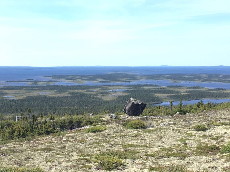
- An Erratic Boulder in Labrador: © Caitlin Lapalme (photographer), Labrador Institute, Fair Use