A Continent Torn Apart
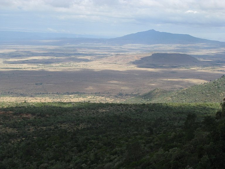
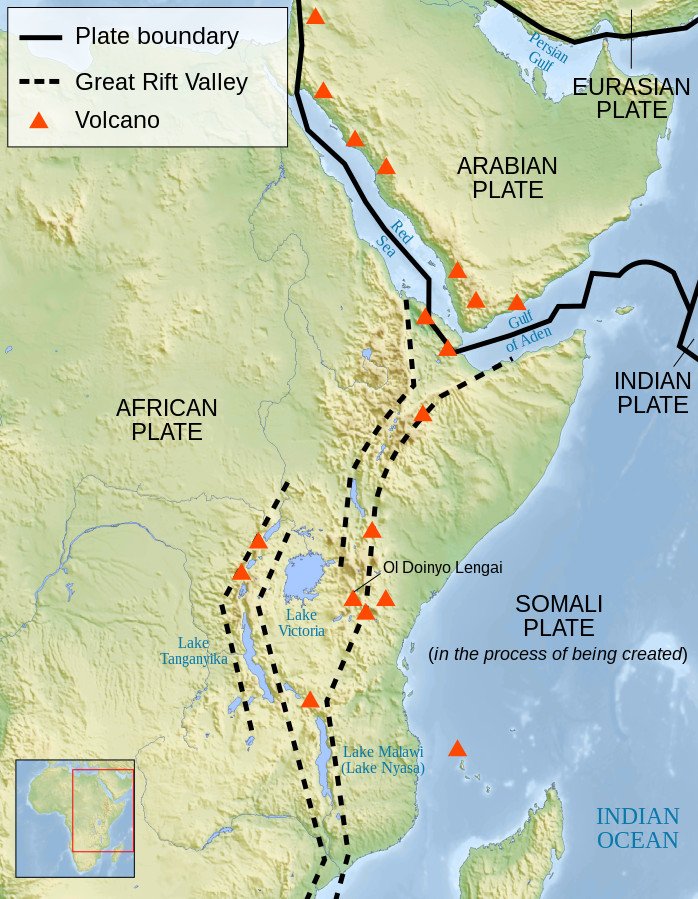
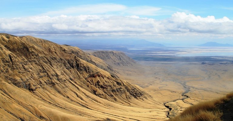
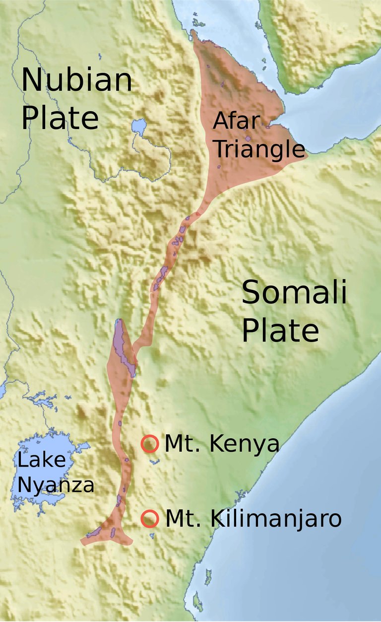
The final section of Chapter VI of Immanuel Velikovsky’s Earth in Upheaval is concerned with the Great Rift Valley. This complex series of contiguous rifts and faults runs for about 7000 km from Lebanon in the Middle East to Mozambique in Africa. In the field of plate tectonics, this was once thought to be a single divergent boundary that was splitting the African Plate into two new plates. It is now recognized that the Great Rift Valley actually comprises several independent fault zones. The largest of these, the East African Rift, is indeed splitting the African Plate into two smaller plates: the Nubian Plate and the Somali Plate. The northernmost component—which is itself the central part of another fault complex, the Dead Sea Transform—is pushing the African and Arabian Plates apart. This component runs from the Beqaa Valley in Lebanon through the Sea of Galilee, the Jordan Valley, the Dead Sea, the Arabah, and the Gulf of Aqaba, before linking up with the Red Sea Rift.
The theory of plate tectonics is now widely accepted by the geological fraternity, but in the early 1950s, when Velikovsky wrote Earth in Upheaval, it was still a highly controversial hypothesis. First proposed in 1912 by the German meteorologist Alfred Wegener, the theory of continental drift initially met with widespread skepticism. It was only in the late 1950s and early 1960s that bathymetric data from the ocean floors led to the discovery of seafloor spreading and subduction, two processes that are now known to complement continental drift. In a series of papers published between 1965 and 1967, the theory of plate tectonics finally took shape and was embraced by the scientific community.
Velikovsky discusses Wegener’s theory at greater length in Chapter VIII.
John Walter Gregory
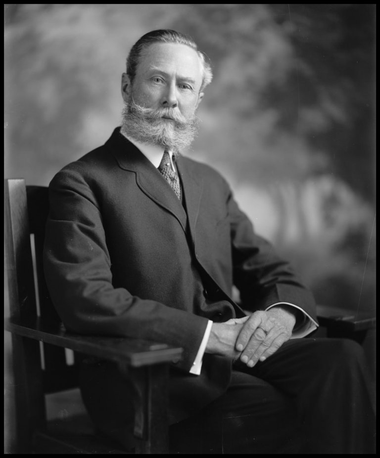
Velikovsky’s first source is the British geologist and explorer John Walter Gregory. In 1892-93, Gregory led an expedition to Mount Kenya, which overlooks the East African Rift. His account of this expedition, The Great Rift Valley, was published in 1896. It was Gregory who gave this feature its current name. He was also the first to suggest that the rift valleys of East Africa were but parts of a much longer geological feature that stretched from Lebanon to the southeast of Africa. The eastern branch of the East African Rift is named in his honour.
Velikovsky also quotes from another of Gregory’s works, Contributions to the Physical Geography of British East Africa, a paper Gregory submitted to the The Geographical Journal upon his return to Britain in 1894.
In 1919, when he was fifty-five, Gregory returned to East Africa and travelled extensively throughout the British colony of Kenya. The fruits of this visit included another paper from which Velikovsky quotes, The African Rift Valleys (Geographical Journal 1920), and another book, The Rift Valleys and Geology of East Africa (London 1921). This latter work repeats the passage which Velikovsky quotes from the 1920 paper.
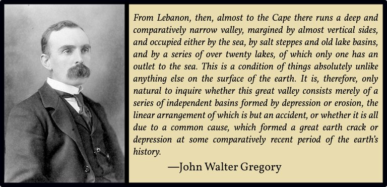
Gregory’s hypothesis that the Great Rift Valley comprises a single geological feature with a single geological cause, extending from the deserts of Northern Syria ... almost to the Cape (Gregory 1894:290), has been modified in recent decades. Nevertheless, what he hypothesized with respect to the Great Rift Valley still holds true as far as the East African Rift is concerned. The current view is that thinning of the lithosphere during the early Miocene Epoch (23 Mya) resulted in the formation of a rift in the African Plate, which has been growing ever since.
In 1936, four years after Gregory’s death, the question of how the Great Rift Valley formed was still being hotly contested. One theory attributed the formation of rifts and faults in general to horizontal compression, while a competing theory attributed it to horizontal tension (stretching). On this point, Velikovsky quotes from the American geologist Bailey Willis, who has already been cited in this chapter of Earth in Upheaval (see Mountain Thrusts in the Alps and Elsewhere). Bailey, you may recall, examined Wegener’s Theory of Continental Drift but ultimately rejected it:
Horizontal force of one type or another has been the active cause of rift valleys, according to previous interpretations. The simplest and earliest thought was that Africa had been pulled apart. A rift valley represented a crack or split. Or if arched up and then stretched, it corresponded with a dropped keystone. On the other hand it was argued that horizontal pressure, causing shortening, had forced the margins of a rift valley up and the valley strip down. Thus the earlier explanations appealed to tension and the later to compression, and the alternative has long divided and still divides two schools of theory in geology. Each school can cite evidence of facts. There are rift valleys where there has been tension. There are also rift valleys where there has been compression. But in each such case the effects of the horizontal pulling or pushing are subordinate to those of the vertical lift that has raised one section or another more than an adjoining one. (Willis 1)
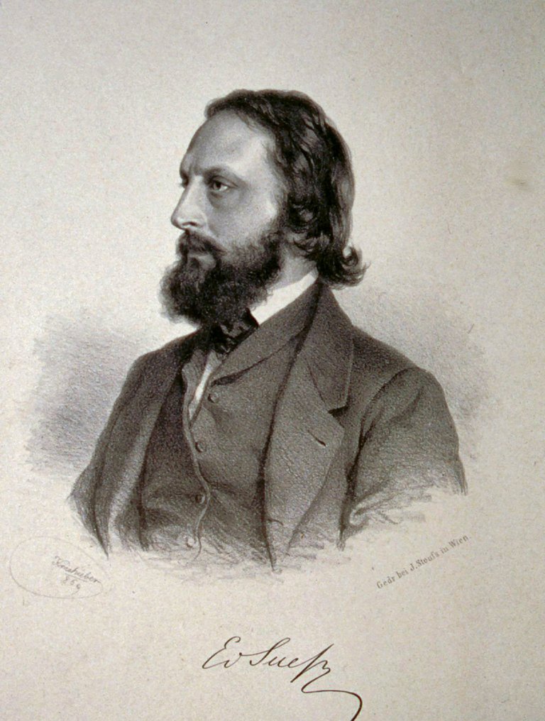
Bailey, then, believed that vertical forces were essential for rifts to form. Velikovsky, however, only repeats Bailey’s quotations of earlier geologists—geologists whose views Bailey rejects. The first of these, the Austrian geologist Eduard Suess, proposed contractionism as the driving force: as the Earth cools, its crust shrinks and cracks. Suess believed that this cracking of the lithosphere had broken apart an ancient supercontinent to which he gave the name Gondwána-Land.
Edouard Suess adopted the view that uplift against gravity could not occur. His epoch-making work, Die Entstehung der Alpen [The Formation of the Alps], which contains the seeds of most of the speculations subsequently elaborated in Das Antlitz der Erde [The Face of the Earth], presented the hypothesis of horizontal displacements and folding, which was followed five years later by the positive negation of absolute uplift:
“There are, however, no vertical movements of any kind of the firm crust, with the exception of those which result directly from the development of folds.” (E. Suess, Ueber die vermeintlichen säcularen Schwankungen einzelner Theile der Erdoberfläche [On the Alleged Secular Fluctuations of Individual Parts of the Earth’s Surface], Verhandlungen der Kaiserlich-Königlichen Geologischen Reichsanstalt (1880)) (Willis 2-3)
Velikovsky repeats Suess’s remarks on the supposed formation of the Great Rift:
So far as the facts are known to me from the foregoing descriptions, it would appear that the opening of fissures of such magnitude can be explained only by the action of a tension, directed perpendicularly to the trend of the split, the tension being relieved in the instant of bursting, that is of opening of the fissure. (Suess 1896:580 ff : Willis 13)
But on the very same page, Bailey rejects this hypothesis:
The affirmations of these statements are generally true; the areas described are depressed. But the negation of uplifts is not true, as was shown by Davis’ and is now generally recognized on physiographic evidence, even by the followers of Suess. Suess’s concept of a sunken graben continues, however, to affect speculation regarding rift valleys and it is desirable to quote his own account; it is difficult, however, to do so adequately without too greatly expanding this summary. It was his habit to assemble all the literature on a region under study, to store his prodigious memory with the descriptions and to form a definite mental picture of the land and its geologic characteristics. Diversity of languages was no embarrassment to the master of all European idioms. Geographic remoteness suggested no strangeness to the man who from his Viennese study had explored the whole world through the observations of others. He readily conceived comparisons between African, Asiatic, American and European lands and their features and made a synthesis of their elements. In his writings he skips from continent to continent in search of illustrations and for the average reader he is as difficult to follow as an airplane for a man on foot. (Willis 13)
Another geologist quoted by Willis is also mentioned by Velikovsky, but only in a footnote:
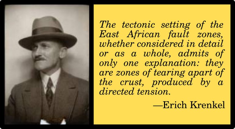
E Krenkel, a German authority, wrote in Die Bruchzonen Ostafrikas (1922): “The tectonic setting of the East African fault zones, whether considered in detail or as a whole, admits of only one explanation: they are zones of tearing apart of the crust, produced by a direct tension ... The action of compressive forces is nowhere recognizable.” (Trans. B. Willis.) (Velikovsky 83 fn 3)
Erich Krenkel was a German geologist who supported the Theory of Continental Drift:
It is logical that the theory of continental drift should find its application to the rift valleys of East Africa. If continental masses have split and separated, the outstanding example of a splitting continent should not be overlooked. Given initially the idea that rift valleys are usually, if not always, bounded by normal, gravity faults, all the conditions of a satisfactory hypothesis may seem to be met. This view is entertained by Krenkel, the leading student of the rift valleys among German geologists and author of the most complete résumé on the subject. His field observations were carried out in 1908 and 1914 and his manuscript was finished in 1921, though he felt at that time that there was need of more work on the problem. His approach to it was enthusiastic. (Willis 22)
A few pages later, Willis mentions Suess, Krenkel and Gregory in the same paragraph:
The difficulty with Suess’s idea of a contracting crust was to find a cause for the condition of parting or pulling away of one part of the superficial crust from another part. Suess gave no explanation; it was simply a fact, as he conceived. Gregory linked the movements with the disappearance of Gondwanaland and great eruptions of molten lava. Wegener found support for the theory of continental drift in a purely hypothetical concept of the African rifts, and Krenkel, who studied them on the ground, became convinced that they represent actual tears or partings (Zerrungen in a Zerreissungszone) of the African continental shield, which is impeded in its northwestward drift by the southeastward drift of Asia in such manner that it is subjected to tensional shearing stresses, to which it has yielded. Unfortunately for the theory, the fact of horizontal tension and parting is not established by evidence; it is, so far as may be judged, a purely subjective concept and is altogether inadequate to carry the load of theory built upon it by Wegener or to sustain the arguments of Krenkel. (Willis 28)
Velikovsky is happy to adopt these catastrophist views as though they were established facts:
After a long debate the consensus restated the view expressed by Eduard Suess, a prominent geologist at the turn of the century ... Suess brought to geology the now generally accepted concept of Gondwana land, a continental mass that occupied the larger portion of the Indian Ocean, and that in a relatively recent subsidence was torn apart and drowned. The subsidence of the Gondwana continent could have caused a strain on western Asia and Africa, and under this tension the land must have been rent and the Great Rift formed. (Velikovsky 83)
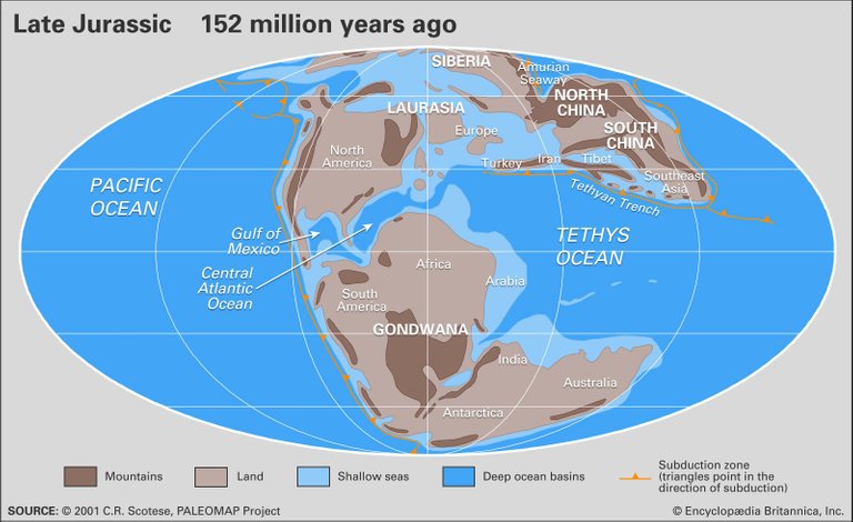
It is curious that Velikovsky seems to look upon Gondwanaland as a sort of Indian Ocean Atlantis, which subsided and was drowned beneath the waves. In fact, it was the break-up of Gondwanaland that led to the creation of the Indian Ocean. Gondwanaland did not subside: it merely broke apart, giving rise to today’s continental landmasses of South America, Africa, Arabia, India, Madagascar, Australia, Zealandia and Antarctica.
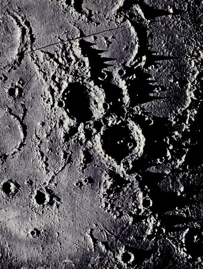
Although it is not really relevant to his thesis of the Earth in upheaval, Velikovsky also quotes Gregory’s theory that the rilles on the surface of the Moon were created by the same process that gave rise to the Great Rift Valley:
The structure of the Rift Valley has, therefore, very varied interests—geological and geographical, on account of its connection with the history of the eastern basin of the Mediterranean, and ethnographical, on account of its explanation of some of the best-known stories in our folklore. But it comes in contact with the problems of science on yet another side. Fig. 2 illustrates the structure of part of the surface of the moon, showing, in addition to the well-known “ring-systems” (usually called volcanoes), a series of long narrow clefts known as “rills.” If all the air and water were removed from the earth, then the Rift Valley would present much the same aspect to an inhabitant of the moon as some of the larger of the lunar rills present to us. So the exploration of the Rift Valley has the additional attraction of offering the possibility of explaining the nature of some features in the surface of the moon. (Gregory 1896:5-6)
The Age of the Great Rift
Today mainstream geologists date the initial break-up of Gondwanaland to the Jurassic Period (180 Mya). The process has continued to the present day, with the Somali Plate breaking away from the rest of the African Plate. As we have seen above, the opening of the Great Rift itself is dated to the early Miocene (23 Mya). Velikovsky, however, would like to date these events to the very recent past:
Gregory followed Suess in linking the Great Rift Valley with “the mountain chains due to the last great uplift of fold mountains” in Europe, Asia, and the Americas. Thus the time of the last uplift, if established, would also clarify the time when Africa suffered the Great Rift ...
Although Gregory thought that the Rift first came into being at an early epoch because of marine fossils found in it he also saw signs of great earth movements along the Rift “at a recent date.” “Some of the fault-scarps are so bare and sharp that they must be of very recent date. This continuation of earth-movements into the human period is one of the most striking features of the district.” Gregory found also that human memory retained recollection of the upheaval. “All along the line the natives have traditions of great changes in the structure of the country.” (Velikovsky 84 : Gregory 1896:236, 6)
The quotation the mountain chains due to the last great uplift of fold mountains, which is not explicitly cited, is taken from Willis’s East African Plateaus and Rift Valleys, where Willis is summarizing the contents of Gregory’s 1920 paper The African Rift Valleys:
Following this definite outline of his hypothesis of the antecedents and conditions of development of the rift valley system, Gregory follows Suess both intellectually and in geologic theory in linking the Great Rift Valley with the “mountain chains due to the last great uplift of fold mountains” in Europe, Asia, and the Americas. (Willis 21)
Willis took the phrase in quotes from the caption to the figure on page 38 of Gregory’s paper.
Far from assigning the initial formation of the Great Rift to the recent past, Gregory originally pushed it further back in time than today’s geologists do:
The first of the series of north and south faults which formed the Rift Valley happened in the Eocene. This is determined by the occurrence of marine fossils, which must have lived in a gulf that ran into the valley from the Indian Ocean. (Gregory 1896:231)
So wrote Gregory in 1896. The Eocene Epoch preceded the Miocene, the epoch in which modern geologists now place the formation of the Great Rift. The Eocene lasted from 56 to 34 Mya. In 1921, however, Gregory did consider the possibility that the Great Rift was much younger than this:
There are two theories as to the age of the Rift Valley. According to the first, its history is geologically short, and this view at once suggests itself on inspection of the valley, as its walls are often as fresh and steep as sea cliffs. That the valley is geologically young is also suggested by tradition and folklore. It is tempting to explain the graphic story of the destruction of Sodom and Gomorrah by the last earth-movements which made the Dead Sea. Similarly, according to an oral tradition of the Somali, when their ancestors crossed from Southern Arabia to Somaliland the two countries were connected by land. The people, too, of Ujiji have a legend that many villages were drowned on the formation of Tanganyika. A story reported by Dr. Oswald (1914, p. 156) represents the subsidence of the Simbi crater as the punishment of an inhospitable village, whose inhabitants all but one perished in the catastrophe. (Gregory 1921:359)
But Gregory is skeptical of these accounts:
These legends, however, may not be actual reminiscences of the Rift Valley movements; they may result, like so much folklore, from attempts to explain local geographic features. The main faults of the Rift Valley were certainly earlier than the oldest known remains of man found along its course. Most of the Rift Valley had been formed by the Pliocene, though the Jordan Valley and the final movements and eruptions belong to the Pleistocene Epoch. It contains no marine Pliocene beds S. of Massawa, and Late Pliocene deposits containing freshwater shells lie upon its floor; hence it was a valley in the Pliocene, though it was not then occupied by the sea. In B.E.A. [British East Africa] some of the Rift Valley faults are younger than the Miocene lavas, and are therefore not earlier than Pliocene. (Gregory 1921:359-360)
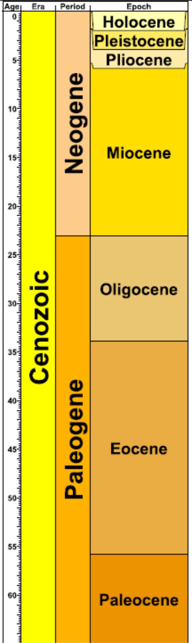
The Pliocene Epoch was quite recent, geologically speaking, extending from about 5.3 to 2.6 Mya. But Gregory did not hold this opinion for long:
That the Rift Valley was not older than Pliocene or Pleistocene was my first impression of it in 1893; but gradually I was forced to the view that the Pliocene movements were the later stage in the development of a much older valley and that the Rift Valley has had a long and complex history. I accordingly suggested a classification (1896, p. 235) of its rocks and earth-movements, which attributed its oldest associated lavas to the Upper Cretaceous and its earliest main faults to the Oligocene. That classification has been regarded as too elaborate and as attributing too great an age to the Rift Valley.
The fuller evidence, however, now available seems fully to confirm that classification. (Gregory 1921:360)
The Oligocene Epoch lasted from 34 to 23 Mya. It followed the Eocene and preceded the Miocene. Gregory, therefore, cannot be cited in support of Velikovsky’s claim that the Great Rift was formed at the end of the last Ice Age.
Velikovsky brings his argument to a conclusion by postulating links between the Great Rift and other major geological features:
The globe was in tension and its crust cracked along a meridian for most of the length of the African continent. The cause may have been the subsidence of the Indian Ocean, or both tension in Africa and subsidence in the Indian Ocean could have a common cause. The mountain ridge on the floor of the Atlantic Ocean may have been produced by the same cause; and the time of the rupture and faulting must have been coincident with one of the periods of mountain formation in Europe and Asia. Those mountains attained their present height in the age of man; the Rift, it is assumed today, was also created largely in the age of man at the end of the Ice Age. (Velikovsky 84-85)
In support of these postulations, he quotes—in a footnote—from Richard Foster Flint’s Glacial Geology and the Pleistocene Epoch, a work that has been cited in several previous chapters:
Flint: Glacial Geology, p. 523: “Late-Pleistocene mountain uplift occurred in the Himalayan region and in the Alps, and large-scale rifting took place in eastern Africa.” (Velikovsky 85 fn 7)
Conclusion
There can be no doubt that large-scale rifting has taken place in eastern Africa in very recent times, but Velikovsky’s claim that the initial formation of the Great Rift Valley and the break-up of Gondwanaland were recent events is not one that modern geologists would take seriously. Nevertheless, the local legends adduced by Gregory should give one pause for thought. The initial rifting may have begun in the remote past, and for much of the following 23 million years it may have continued in a gradualist manner, but this does not preclude the possibility that this uniformitarian process was punctuated by short, isolated periods of catastrophist rifting—as attested to by local legends.
And that’s a good place to stop.
References
- Richard Foster Flint, Glacial Geology and the Pleistocene Epoch, John Wiley And Sons, Inc, New York (1947)
- John Walter Gregory, Contributions to the Physical Geography of British East Africa, The Geographical Journal, Volume 4, Number 4, Pages 289-315, 408-424, 505-524, Royal Geographical Society, London (1894)
- John Walter Gregory, The Great Rift Valley, John Murray, London (1896)
- John Walter Gregory, The African Rift Valleys, The Geographical Journal, Volume 56, Number 1, Pages 13-47, Royal Geographical Society, London (1920)
- John Walter Gregory, The Rift Valleys and Geology of East Africa, Seeley, Service & Co Limited, London (1921)
- Erich Krenkel, Die Bruchzonen Ostafrikas [The Fault Zones of East Africa], Gebrüder Borntraeger, Berlin (1922)
- James Nasmyth & James Carpenter, The Moon: Considered as a Planet, a World, and a Satellite, John Murray, London (1874)
- Eduard Suess, Die Entstehung der Alpen, Wilhelm Braumüller, Vienna (1875)
- Eduard Suess, Über die vermeintlichen säcularen Schwankungen einzelner Theile der Erdoberfläche, Verhandlungen der Kaiserlich-Königlichen Geologischen Reichsanstalt, Number 11, Pages 171-180, Alfred Hölder, Vienna (1880)
- Eduard Suess, Die Brüche des östlichen Afrika, Denkschriften der Kaiserlichen Akademie der Wissenschaften, Mathematisch-Naturwissenschaftliche Classe, Volume 58, Pages 555–584, Vienna (1891)
- Eduard Suess, Hertha B C Sollas (translator), The Face of the Earth [Das Antlitz der Erde], Volumes 1-5, Clarendon Press, Oxford (1904-24)
- Immanuel Velikovsky, Earth in Upheaval, Pocket Books, Simon & Schuster, New York (1955, 1977)
- Bailey Willis, East African Plateaus and Rift Valleys, Carnegie Institution of Washington, Washington, DC (1936)
Image Credits
- The Great Rift Valley and Mount Kenya: © shankar s (photographer), Creative Commons License
- Tectonic Map of the East African Rift: © Sémhur (designer), Creative Commons License
- John Walter Gregory: Anonymous Photograph (1932?), Public Domain
- Bailey Willis: © The Granger Collection Ltd, Granger Historical Picture Archive, Fair Use
- Eduard Suess: Josef Kriehuber (lithographer), Peter Geymayer (photographer), Public Domain
- Erich Krenkel: Leipzig University Archive, N03254, Fair Use
- Laurasia and Gondwanaland: © Christopher R Scotese, PALEOMAP Project, Fair Use
- East African Rift: East African Rift, Tanzania, © Joanna Rigby-Jones (photographer), shutterstock, Fair Use
- Geological Timescale: © International Commission on Stratigraphy, Fair Use
- The Gregory Rift: © Aymatth2 (designer) & Bamse (designer), Creative Commons License
.jpg)

Thanks for your contribution to the STEMsocial community. Feel free to join us on discord to get to know the rest of us!
Please consider delegating to the @stemsocial account (85% of the curation rewards are returned).
You may also include @stemsocial as a beneficiary of the rewards of this post to get a stronger support.