Kettle Lakes, Moraines and Glacial Erratics: Evidence of the Ice Age in My Community
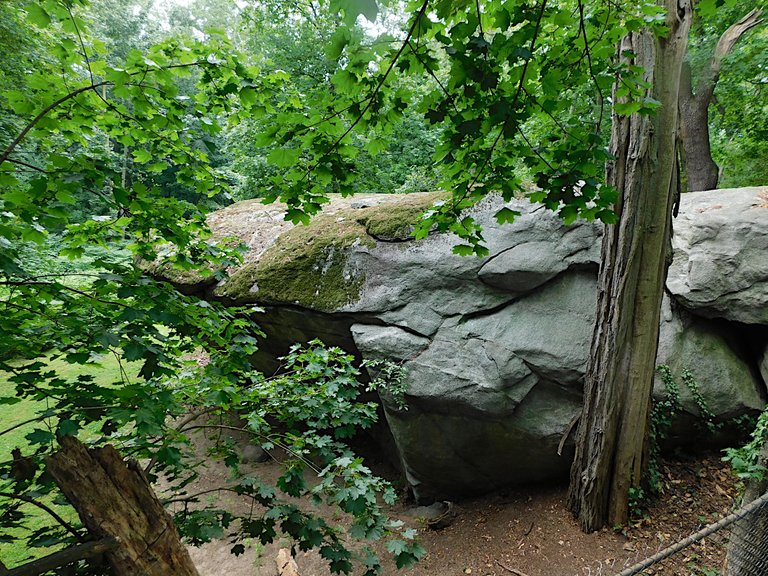
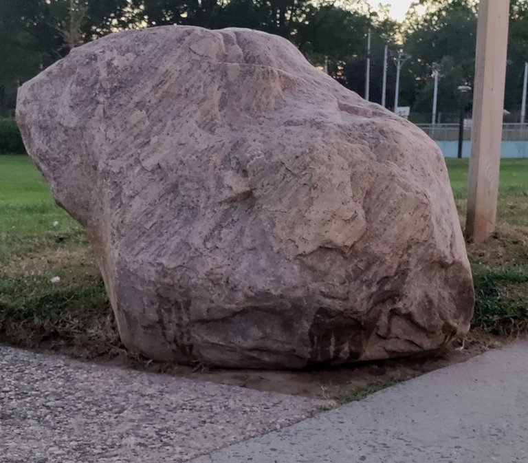
Many times I have driven past the boulder featured in the picture above. The first time may have been in the early '80s. The boulder is located on Shelter Rock Road in Manhasset, New York. The neighborhood around there is called Shelter Rock. Both the road and the area are named after the boulder I drove past and never saw--Shelter Rock.
Finally, this week, I decided to find the rock, and take a picture. I already knew it was a remnant of the last glaciation on Long Island. It is called a 'glacial erratic'--a boulder left behind by retreating glacial ice.
Extreme Boundary of the Ice-sheet, Last glaciation in North America

Credit:Internet Archive Book Images (1892), Public domain. The glacial sheet (Wisconsin glaciation) covered almost all of New York State except a small slice of what would be Long Island, and a tiny piece of southwestern New York.
Can a rock tell a story? This one can, if we care to open the pages and read beyond the outer appearance. It can tell of geologic prehistory, and it can tell the anthropological story, that tracks human settlement in the area.
Traces of the Matinecock People that date back to 1000 B.C. have been found around Shelter rock and along other North Shore Long Island communities.
It is said that the name Shelter Rock came from the Matinecock, who would find shelter under the rock's overhang during rain storms.
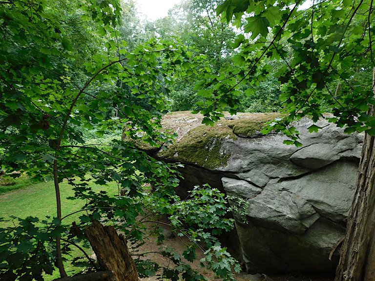
Another View of Shelter Rock, Taken From Behind a Fence
@agmoore
When the first Dutch explorer, David Pietersz DeVries, landed on the North Shore of Long Island, he recognized the richness of the territory. He saw bountiful waters with abundant oyster beds. He exclaimed that the oysters were, "a foot long and broad in proportion ..."
DeVries promptly named the bay in which he had landed, Oyster Bay. He bartered with the Matinecock for pieces of their land. The name Oyster Bay is used today.
The Matinecock were eventually pushed off their lands, until, finally, in 1656 Thomas Hicks drove the last of them away in the battle of Madnan's Neck. The battle took place three miles from Shelter Rock.
From that day, 377 years ago, Long Island has undergone rapid development. Evidence of the Matinecock has almost been completely erased (though not entirely) but evidence of the glaciation has been ineradicable. Today we see proof of that geological event not only in the glacial erratic boulders around the island, but also in the landscape that has endured.
The island is split, literally in half, north to south, along the terminal line of the last glacier.
Topographical Map of Long Island
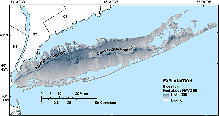
U.S. Geological Society: Public domain
When the glacier retreated (Wisconsin glaciation) some 10,000 to 11,000 years ago, it did not do so as a unified sheet of ice. It pulled back in fits and starts. One source I consulted described glaciers as dirty. They carry with them debris and therefore leave a trail behind of rocks and other material they have collected.
On Long Island, as the ice melted (glacier retreated) it left behind in the northern region rocks, sediment and debris it had picked up when it moved into the area. The area on the island where the deposits were left behind is known as a terminal moraine. There are two terminal moraines on Long island, the Ronkonkoma Moraine and the Harbor Hill Moraine (see the map above for boundaries of these moraines).
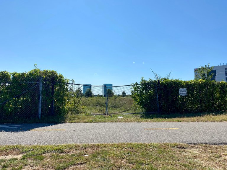
Rocky Deposits on Bar Beach, Located in the Harbor Hill Moraine
@agmoore, on LIL, the LMAC image library.
According to the New York City Parks Department, without the terminal moraines, Long Island would not exist. The bedrock for the island is well below sea level.
Although evidence of the glacial retreat is evident on the North Shore in the rocks and debris left behind, the South Shore tells a different story.
The glacier did not reach the South Shore, but water from the melting glacier washed off from the terminal ridge and flowed across the southern half of the island. This glacial 'outwash' created a great prairie, the Hempstead Plains. At one time, the Hempstead Plains comprised the largest prairie east of the Mississippi River.
Tract of Land Preserving Remains of the Hempstead Plains
AITFF. Used under Creative Commons Attribution-Share Alike 4.0 International license.
As the picture above shows, much of the original prairie is gone. Development (Nassau Community College buildings are in the distance) has destroyed most of it. The portion shown here is part of an official preserve, meant to maintain this vital part of the environment, and Long Island's physical history.
As one goes further south on Long Island, to the South Shore beaches, one sees more evidence of the glacial outwash. The South Shore's sandy beaches, without the debris and rocks of the moraine, are testaments to the glacial melt.
The Smooth Sands of Tobay Beach, on Long Island's South Shore
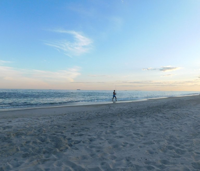
@agmoore
If we take a short trip due north from Tobay, up past the border of Harbor Hill Terminal Moraine (check the map at the beginning of the blog), we will find a rocky, rubble-strewn strip of coast. Here is evidence of the glacier that retreated, and the debris it deposited.
Compare the consistency of the North Shore and South Shore sands. The beaches of Long Island speak as eloquently of the island's geological past, as does Shelter Rock.
Rock-Strewn Beach of Centre Island, on Long Island's North Shore
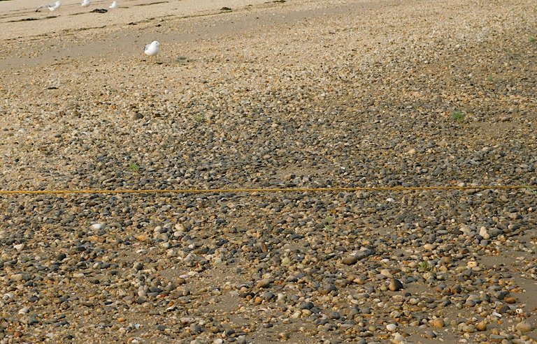
@agmoore
A Glacial Erratic (Large Boulder) on the North Shore's Bar Beach
@agmoore
I've been writing about how the glacier retreated from Long Island more than 10,000 years ago. But that retreat did not occur in one year or two years. It began 18,000 years ago. As the glacier made its way, it carved the land below.
At the time the glacier came, some 20,000 to 22,000 years ago, there was no Long Island, or New York Harbor. The glacier shaped these land forms and deposited sediment. The rising sea level from the melting ice created the island and the bedrock under the island was buried under rocks and sediment.
Today, the North Shore, where sediment and rocks were deposited, is not only rockier but is also higher than the South Shore. As a consequence, flooding on the South Shore is more severe, though both shores are vulnerable to flooding.
2017 Map Showing Flooding Areas After Hurricane Sandy
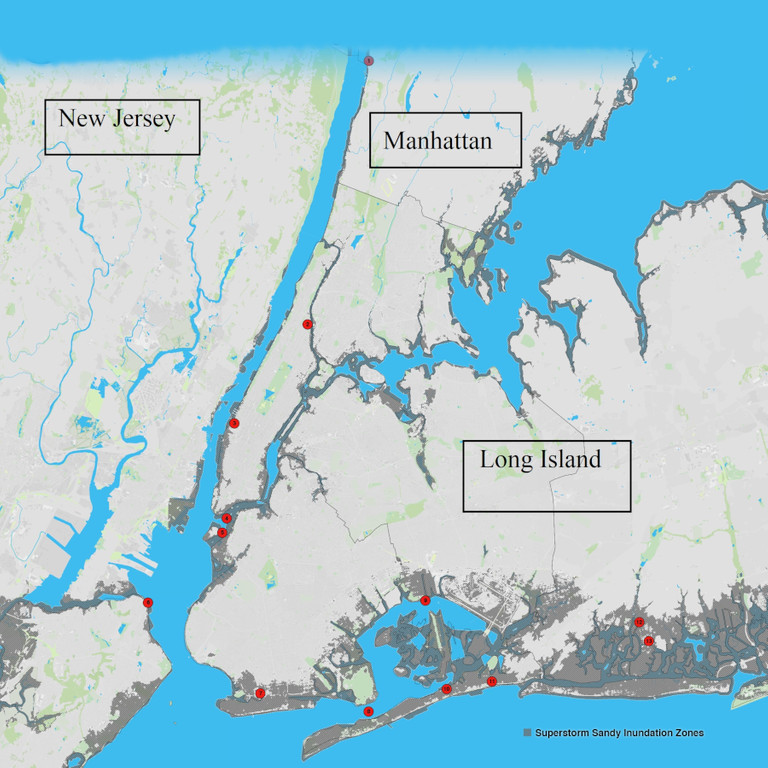
Metropolitan Transportation Authority. Used under CC Attribution 2.0 Generic license.
The 'inundation' map above shows the flooding that occurred in the NY Metro area during Hurricane Sandy (2012). As the map reveals, the South Shore of Long Island saw significantly more flooding than the North Shore.
Just as Long Island owes its existence, its shape and topography, to a retreating glacier, it is other glaciers, retreating around the world, that may lead to the island's demise. It has been suggested that rising sea levels (partly caused by melting glacial ice) may inundate the whole South Shore by 2100. The coastal communities and beaches of that part of the island may be swallowed up by the sea.
Flooding at Bayshore (South Shore Community), 2014
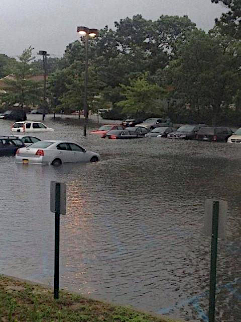
NY Metropolitan Transportation Authority. Used under CC Attribution 2.0 Generic license. The flooding at the parking lot did not take place during Hurricane Sandy. The rain fell during a record precipitation event on the Island. On August 12-13, 13.57" of rain fell in a 24 hour period. The record rainfall was measured in the neighboring community of Islip.
Kettle Lakes
I was trying to discover more evidence of the last glaciation on Long Island when I came across a description of kettle lakes. A kettle lake is formed when a piece of glacial ice breaks off. As that chunk of ice melts, the debris it contained settles around the edges of the melt. Eventually, a hole is formed and water from the melted ice fills the hole.
I discovered we have just such a lake, Lake Success, not far from my home. As a matter of fact the lake is almost adjacent to the hospital where my daughter was born.
As was true of Shelter Rock, this lake also has a history rooted in the people who originally settled the area. These people called the area "sacut", which meant outlet of a pond. According to town historian Dr. Jack Binder, the word was corrupted over time to the word "success".
Lake Success
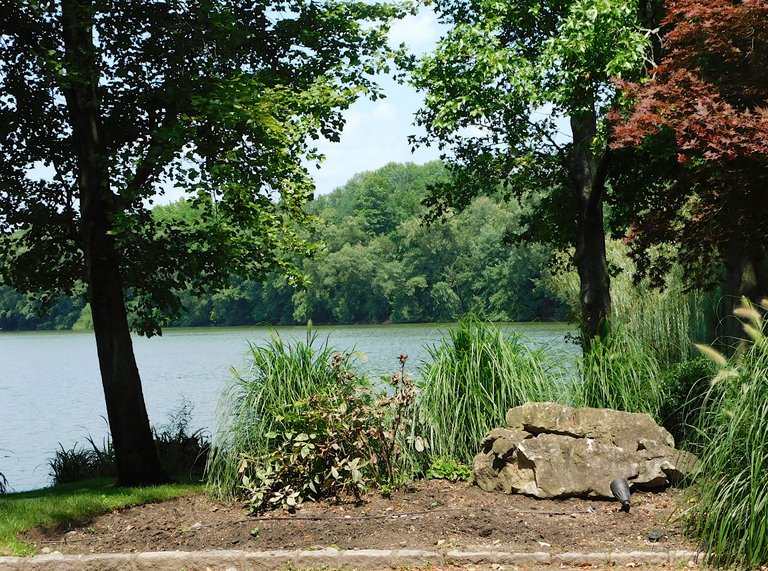
@agmoore
I tried to get close to the lake, but as was true with Shelter Rock, this remnant of the Ice Age is not accessible. I had to take this shot from the side of the road, at a bit of a distance.
Here is another perspective. On the other side of the lake is a golf course. I was standing on the edge of someone's lawn when I took this.
Lake Success
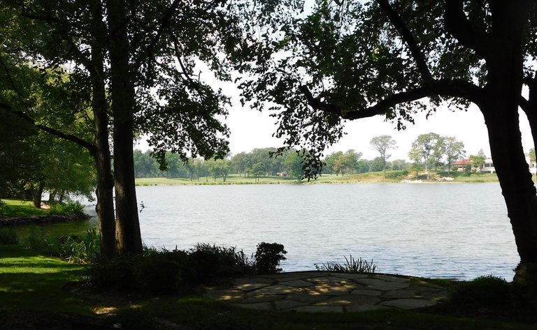
@agmoore
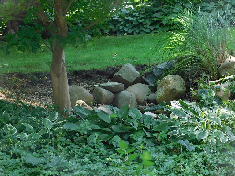
There were many of what appear to be glacial erratics near the lake. Across the street I saw this collection in a yard. These probably were there when the house was originally built.
_(20636279163).jpg)
.jpg)
Conclusion
When we speak of an Ice Age, we generally think of something that happened in the past. My recent readings informed me that we are still in an Ice Age. According to the Utah Geological Survey, an Ice Age has warmer and colder periods, times when glaciers move across the land and times when they retreat. The warmer periods, between glacier movement, are called interglacials. When a glacier advances the era is referred to as a glacial.
They say you should write what you know. I didn't know much about glaciers when I started this piece, but I did know my community. It was fun applying what I learned about glaciers to my own community. I look at ordinary, every-day sights now with fresh eyes. It is all so much more interesting.
Thank you for reading. Everyone, be well and peaceful. Hive on!
@quantumg, on the LIL Gallery
Selected Sources
https://www.brownstoner.com/history/honoring-past-residents-northeast-queens-matinecock-indians/
https://slideplayer.com/slide/4148110/
https://www.garviespointmuseum.com/geology.php
https://sites.williams.edu/geos101/mid-atlantic/geological-history-of-long-island/
https://en.wikipedia.org/wiki/Shelter_Rock_(North_Hills,_New_York)
https://longislandsoundstudy.net/2020/10/3rd-annual-estuary-day-goes-digital/
https://www.ontarioparks.com/parksblog/kettle-lakes-land-shaped-icebergs/
https://longislandsoundstudy.net/2020/10/3rd-annual-estuary-day-goes-digital/
https://www.ontarioparks.com/parksblog/kettle-lakes-land-shaped-icebergs/
https://geology.utah.gov/map-pub/survey-notes/glad-you-asked/ice-ages-what-are-they-and-what-causes-them/
https://www.nps.gov/sahi/learn/historyculture/upload/HRS_TRH_SAHI_2007.pdf
http://centreisland.org/wp-content/uploads/2013/03/History-of-Centre-Island.pdf
https://www.jeremynative.com/onthissite/wiki/creation-of-long-island/
https://flatbushgardener.blogspot.com/2013/09/hempstead-plains-long-islands-remnant.html
https://patch.com/new-york/gardencity/history-of-the-hempstead-plains
https://www.newyorknature.us/ice-age-new-york/
https://storymaps.arcgis.com/stories/4bf3df46568f4f3e93d222ac6ae08fee
https://www.nationalgeographic.com/environment/article/hurricane-sandy
https://www.climatehotmap.org/global-warming-locations/new-york-city-ny-usa.html
https://www.weather.gov/okx/HistoricFlooding_081314
https://project.geo.msu.edu/geogmich/kettle_lakes.html
https://www.villageoflakesuccess.com/History_of_Lake_Success.pdf
Congratulations @agmoore! You have completed the following achievement on the Hive blockchain And have been rewarded with New badge(s)
Your next target is to reach 14500 replies.
You can view your badges on your board and compare yourself to others in the Ranking
If you no longer want to receive notifications, reply to this comment with the word
STOPCheck out our last posts:
Thank you, @hivebuzz!
All good @agmoore! You're amazing on Hive! Don't stop now, achieve that new goal!
Nature is the most beautiful thing on earth
There is nothing as beautiful as nature
All of these pictures are beautiful
Hello @rafzat,
Thank you.
I enjoyed taking these pictures because, you're right--nature is beautiful.
This post rocks! 😆
I once took a course on geophysics, and it was the most tortuous experience of my life, but I learned quite a bit about the Earth's geologic innards. I wish I had appreciated it more. Your post reminded me of many of the topics we discussed and analyzed. Great stuff!
😅
I think geophysics might be hard (anything with the word physics in it scares me), but this was fun. I like to spend time in the world of illusion, but it's really interesting to learn about something as material as the ground we walk on.
Thanks for stopping by, @litguru
I myself am very fond of living in such a natural place area and everyday I go to a place and see such beautiful trees and many natural things which gives me so much peace all these pictures yhey are very beautiful.
Thank you! We share a love of nature. Thank you for reading and commenting, @djbravo
Most welcome dear.
Fantastic post. Very informative as usual, thanks!
I appreciate your kind comment, @friend @one-eye
Thanks for your contribution to the STEMsocial community. Feel free to join us on discord to get to know the rest of us!
Please consider delegating to the @stemsocial account (85% of the curation rewards are returned).
Thanks for including @stemsocial as a beneficiary, which gives you stronger support.
Thank you very much for your support, @stemsocial!
https://twitter.com/LovingGirlHive/status/1690441751298011136
I loved the post, when I finished I realized that it had almost two thousand words and the truth is that it didn't take me long to read it at all.
Thank you! I used to teach social studies to high school students. I learned that I had to work hard to hold their attention 😄. When I write, I try to use the same principle. Work really hard so that delivery of information is painless to the reader.
I'm glad the approach was effective for at least one of my readers :)